Planey
| Planey | ||
|
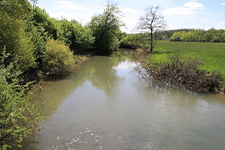
The Planey about two kilometers below its source |
||
| Data | ||
| Water code | FR : U0460500 | |
| location | France , Bourgogne-Franche-Comte region | |
| River system | Rhône | |
| Drain over | Sémouse → Lanterne → Saône → Rhône → Mediterranean | |
| source | east of Anjeux 47 ° 50 ′ 2 ″ N , 6 ° 12 ′ 49 ″ E |
|
| Source height | approx. 234 m | |
| muzzle | in Varigney in the Sémouse coordinates: 47 ° 50 ′ 2 " N , 6 ° 12 ′ 49" E 47 ° 50 ′ 2 " N , 6 ° 12 ′ 49" E |
|
| Mouth height | approx. 227 m | |
| Height difference | approx. 7 m | |
| Bottom slope | approx. 1 ‰ | |
| length | 6.7 km | |
The Planey is a river in France that runs in the Bourgogne-Franche-Comté region in the Haute-Saône department .
geography
Source du Planey
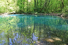
The Source du Planey (Eng. Source of the Planey ) is a large karst spring from the rock of the Vôge . The approximately 32 m deep, blue spring pot is located in a wooded area east of Anjeux . About 250 m below the source, the 10.5 km long Dorgeon flows into the Planey.
course
The Planey generally drains in a south-westerly direction and flows into the Sémouse as a right tributary after 6.7 km in the municipality of Varigney .
Tributaries
- Dorgeon (right)
- Chanois (right)
- Ruisseau des Auvets (right)
- Ruisseau de Coué (right)
Web links
Commons : Planey - collection of images, videos and audio files

