
Sources d'Arcier
| Sources d'Arcier | ||||
|---|---|---|---|---|
 The Source du Martinet |
||||
| location | ||||
| Country or region | Doubs department , Bourgogne-Franche-Comté region ( France ) | |||
| Coordinates | 47 ° 16 ′ 1 ″ N , 6 ° 7 ′ 16 ″ E | |||
| height | 275 m | |||
|
||||
| geology | ||||
| Mountains | law | |||
| Source type | Karst springs | |||
| Hydrology | ||||
| River system | Rhone | |||
| Receiving waters | Ruisseau d'Arcier → Doubs → Saône → Rhône → Mediterranean | |||

Coordinates: 47 ° 16 ′ 1 ″ N , 6 ° 7 ′ 16 ″ E
The Sources d'Arcier (dt. Sources of Arcier ) are several karst springs northeast of Besancon in Vaire-Arcier in Doubs in the region Bourgogne Franche-Comté in France .
geography

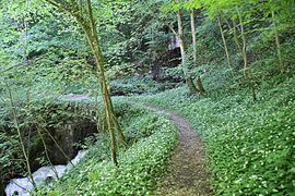
The karst springs are located at 275 m on the northern edge of the Jura on the left bank of the Doubs . You are in a wooded area on the outskirts of the municipality of Arcier. The two largest springs are the Source Bergeret and the Source du Martinet . The longer Ruisseau Bergeret and the more watery Ruisseau d'Arcier are the two streams that spring from the springs. They meet after about 300 m at Départementsstraße 323 and then flow into the Doubs. The approximately 100 km² catchment area of the sources of Arcier is the Saône plateau.
history

The water of the Arcier springs has been drawn since ancient Roman times . The spring water was led from the karst springs to Vesontio (now Besançon ) in 170 through an aqueduct that was destroyed in the middle of the 5th century . The aqueduct had a gradient of 22 m by 12 km.
Between 1850 and 1854, a new aqueduct to Besançon, in the Château d'eau de la source d'Arcier (Eng. Water tower of the sources of Arcier ), was built. Today the water is taken directly from the source cave of the Source du Martinet .
The springs used to run a powder mill , which was later converted into a chapel.
flora
Wild garlic grows in the forests around the springs .
Picture gallery

Source Bergeret

Source Arcier
Wild garlic at the Source du Martinet


See also
Web links
Individual evidence
- ↑ Google Earth