South Keeling Islands
| South Keeling Islands | ||
|---|---|---|
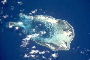
| NASA image of South Keeling | ||
| Waters | Indian Ocean | |
| archipelago | Coconut islands | |
| Geographical location | 12 ° 10 ′ S , 96 ° 52 ′ E | |
|
|
||
| Number of islands | 23 | |
| Main island | West Iceland | |
| length | 17.3 km | |
| width | 12.1 km | |
| Land area | 13 km² | |
| Lagoon area | 140 km² | |
| Residents | 550 | |
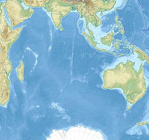
| Map of the Cocos Islands | ||
The South Keeling Islands ( German Südkeelinginseln ) are one of the atolls of the Cocos Islands , in addition to about 27 km to the north lies North Keeling Iceland . The Australian atoll is located in the Indian Ocean about 2,930 km northwest of Perth , 3,685 km west of Darwin , 960 km southwest of Christmas Island and more than 1,000 km southwest of Java and Sumatra .
The South Keeling Islands have two inhabited islands with a combined population of 550, West Island and Home Island . The other islands are not permanently inhabited. A Malay ethnic group of just over 400 people live on the islands , the Cocos Malays , who live mainly in Bantam on Home Island . There are also around 150 Australians, most of whom live on West Island.
history
First settlement
Captain William Keeling 1609 was the first to reach the uninhabited Cocos Islands. The South Keeling Islands were colonized by the slave trader and businessman Alexander Hare in 1826 and by John Clunies-Ross in 1827 with Malays , who were kept by them as serfs . On the other hand, there was an unsuccessful revolt on December 22, 1837. As a result, John Clunies-Ross, who called himself King Ross I, pushed through an agreement that forced the Malay , Bantamese and European families living on the Cocos Islands to live in his homes and work for him or to leave the island. Coconut palms were planted on the islands and copra and coconut oil were made from them. This was exported while other products had to be imported.
First and Second World War
In World War I it came close Horsburgh Iceland and Direction Iceland to a sea battle between the light cruiser SMS Emden and the light cruiser HMAS Sydney , which forced the Emden to the task.
The Allied military occupied the islands in World War II from 1941. In March 1941, a Japanese destroyer attacked the telecommunications cable station located on Direction Island ; further bombings on the islands followed. 3000 soldiers were stationed here; there were also 1,800 civilians on the islands, 900 of whom had to be returned to their homeland after the war.
In 1944 an Australian government administrator came to Home Island for the first time .
After 1945
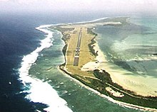
The Allies built a runway on West Iceland in March 1945 , which was shut down again in 1946. In 1951 the Australian government took control of the islands and paved the runway that Qantas used for refueling on their flights to Europe via South Africa .
In 1953 the first government buildings were built on West Island , followed by Australian government, administrative and hospital staff. In the late 1960s, a United Nations delegation came to investigate human rights violations in the South Keeling Islands .
In 1978 Australia made the Cocos Islands one of its outer territories when it bought the islands for AUD 6.250 million from the Clunies-Ross dynasty . In 1979 the Cocos (Keeling) Islands Shire was founded on Home Island , but it was not until 1984 that the government was able to expand to all of the Cocos Islands.
In 1987 copra production was stopped due to inefficiency. Unemployment among the islanders has been high since then.
List of islands
The following table shows the islands of the South Keeling Islands starting from the north in a clockwise direction. An area of 0.00 km² means that the respective island is now regularly flooded.
| Malay name | English name | Area (km²) |
|---|---|---|
| Pulau Luar | Horsburgh Island | 1.04 |
| Pulau Tikus | Direction Island | 0.34 |
| Pulau Pasir | Workhouse Island | 0.00 |
| Pulau Beras | Prison Island | 0.02 |
| Pulau Gangsa | Woeplace islets | <0.01 |
| Pulau Selma | Home Iceland | 0.95 |
| Pulau Ampang Kechil | Scaevola Islet | <0.01 |
| Pulau Ampang | Canui Island | 0.06 |
| Pulau Wa-idas | Ampang Minor | 0.02 |
| Pulau Blekok | Goldwater Island | 0.03 |
| Pulau Kembang | Thorn Island | 0.04 |
| Pulau Cheplok | Gooseberry Island | <0.01 |
| Pulau Pandan | Misery Island | 0.24 |
| Pulau Siput | Goat Island | 0.10 |
| Pulau Jambatan | Middle Mission Isle | <0.01 |
| Pulau Labu | South Goat Island | 0.04 |
| Pulau Atas | South Iceland | 3.63 |
| Pulau Kelapa Satu | North Goat Island | 0.02 |
| Pulau Blan | East Cay | 0.03 |
| Pulau Blan Madar | Burial Island | 0.03 |
| Pulau Maria | West Cay | 0.01 |
| Pulau Kambling | Keelingham Horn Island | <0.01 |
| Pulau Panjang | West Iceland | 6.23 |
| Pulau Wak Bangka | Turtle Island | 0.22 |
Individual evidence
- ↑ Census 2011 of the Australian Bureau of Statistics (English), accessed April 28, 2015
- ↑ a b environment.gov.au : Place Details: Direction Island (DI) Houses, Air Force Rd, West Island Settlement, EXT, Australia, History, in English, accessed September 16, 2011
- ^ Regional Surveys of the World: The Far East and Australasia 2003 . 34th Edition. P. 145 f. Routledge 2002. ISBN 1857431332 Online on Google Books


