North Keeling
| North Keeling | ||
|---|---|---|
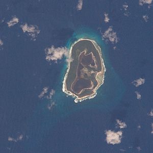
| NASA image of North Keeling | ||
| Waters | Indian Ocean | |
| archipelago | Coconut islands | |
| Geographical location | 11 ° 50 ′ S , 96 ° 49 ′ E | |
|
|
||
| Number of islands | 1 | |
| Main island | North Keeling Island | |
| Land area | 70 ha | |
| Lagoon area | 50 ha | |
| total area | 1.2 km² | |
| Residents | uninhabited | |
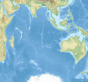
| Map of the Cocos Islands with the location of North Keeling (above) | ||
North Keeling is a small uninhabited atoll about 1.2 km² in size, located about 25 km north of Horsburgh Island . It is the northern and smaller of the two atolls of the Australian Cocos Islands and consists of only one island. The archipelago is located about 2,930 km northwest of Perth , 3,685 km west of Darwin , 960 km southwest of Christmas Island and more than 1,000 km southwest of Java and Sumatra . The closest mainland point to Australia is Cape Low Point on the North West Cape Peninsula at a distance of approximately 2,100 km.
North Keeling, together with the approximately 1.5 km² surrounding shallower coastal waters, forms the Pulu-Keeling National Park , one of the smallest national parks in Australia .
North Keeling is a C-shaped island, ie an almost closed ring that only forms a 50 m wide opening on the east side; the internal lagoon covers an area of 0.5 km². The island is home to the endangered and endemic Keeling rail as well as other breeding seabirds .
history
The Cocos Islands are believed to have been sighted by the British captain William Keeling in 1609 and named after him; he was on a journey of the East India Company from Java to the Dutch East Indies . North Keeling was first entered in 1749 by a Swedish captain named Ekeberg to check on the coconut trees ; In 1789 the British hydrographer Alexander Dalrymple mapped the island.
In 1836 North Keeling was sighted by Captain Robert FitzRoy and Charles Darwin on HMS Beagle , who, like others, were unable to land.
In the 19th century, some Europeans suffering from beriberi were abandoned on the islands because the disease was considered contagious at the time. Some of the graves of these people are on the island, as are those of German sailors from Emden .
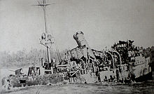
The SMS Emden
During the First World War , on November 9, 1914, the German warship SMS Emden , a light cruiser , suffered several heavy hits from the Australian cruiser HMAS Sydney near the island . The captain Karl von Müller deliberately set the damaged ship aground on the island, soon afterwards the crew surrendered to the enemy. Graves of the fallen German sailors and parts of the wreck are on the island, some of it is under water. In 1950, Japanese entrepreneurs removed all usable metal parts from the shipwreck.
Breeding ground for sea birds
Between the First and Second World War groups were about 20 Cocos Malays on North Keeling for 14 days to win wood and with coconuts and birds for their Home Iceland to supply. By the 1970s and 1980s, they had better boats and handguns available for seabird hunting, which led to the decline of nesting sites in the seabird colonies.
Pulu Keeling National Park
- Main article : → Pulu Keeling National Park
In 1986 an agreement was reached between the Australian National Parks and Wildlife Service and the Cocos Malays , which resulted in a ban on hunting and sustainable management on North Keeling. In 1989, Cyclone John devastated the red-footed booby colony on North Keeling. Since then, hunting them has been banned entirely.
The Pulu Keeling National Park, which is of great importance as a breeding ground for rare sea birds and sea turtles , was established on December 12, 1995. It is the habitat of the endemic Keeling's common rail, Gallirallus philippensis andrewsi , and the dwarf angelfish , Centropyge . It is assumed that there are about 750 to a maximum of 1,000 specimens of the Keeling raspberry. The park is recognized as a wetland of international importance under the Ramsar Convention since March 17, 1996 and is listed as Ramsar Site 797.
The national park should preserve the area in its natural state; Access is only possible with a permit from the National Park Administration.
literature
- Boudewijn Büch: Eenzaam , 1992, pp. 84-94. ISBN 9789041331038
Web links
- Pulu Keeling National Park (English)
Individual evidence
- ↑ environment.gov.au : Pulu Keeling National Park , in English, accessed September 10, 2011
- ↑ a b Anon. (2004). Pulu Keeling National Park Management Plan . Australian Government. ISBN 0-642-54964-8
- ↑ environment.gov.au ( Memento of the original from September 3, 2011 in the Internet Archive ) Info: The archive link was inserted automatically and has not yet been checked. Please check the original and archive link according to the instructions and then remove this notice. : Pulu Keeling National Park: Fauna , in English, accessed September 10, 2011


