Southeast Harbor
| Southeast Harbor | ||
| Geographical location | ||
|
|
||
| Coordinates | 52 ° 36 ′ S , 169 ° 11 ′ E | |
| Region ISO | NZ | |
| country | New Zealand | |
| Sea access | Pacific Ocean | |
| Data on the natural harbor | ||
| Port entrance | 830 m wide | |
| length | around 1.7 km | |
| width | Max. 0.83 km | |
| Coastline | around 3.8 km | |
| Tributaries | Southeast Stream | |
| Photography of the natural harbor | ||
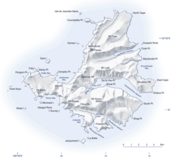
 Map of Campbell Island with Southeast Harbor in the southeast |
||
Southeast Harbor is a natural harbor on the sub-Antarctic Campbell Island in the southern Pacific Ocean . The island is one of the offshore islands of New Zealand .
geography
The Southeast Harbor is located on the southeast side of Campbell Island and extends 1.7 km into the island. The entrance to the natural harbor extends over a width of 830 m, while the width of the water inland continuously decreases to 160 m towards the end of the bay. The coastline measures around 3.8 km in length.
The mountains surrounding Southeast Harbor rise to a height of 416 m . The only tributary to the natural harbor is the 1.85 km long Southeast Stream , which rises on the southern flank of the 558 m high Mount Honey .
See also
literature
- Gordon S. Maxwell : Subantarctic Campbell Island . In: Tane . Vol. 16 , 1970, pp. 5–19 (English, online [PDF; 3.4 MB ; accessed on June 11, 2018]).
Web links
- Campbell Island . (JPG 4.0 MB)Land Information New Zealand,accessed on June 11, 2018(English, detailed topographic map ofCampbell Islandwith its small neighboring islands and rocky islands).
Individual evidence
- ↑ Coordinates and longitudes were partly made using Google Earth Version 7.3.1.4507 on June 11, 2018.
- ^ Campbell Island . (JPG 4.0 MB) Land Information New Zealand , accessed on June 11, 2018 (English, detailed topographic map of Campbell Island with its small neighboring islands and rocky islands).
