Southeast Peninsula (St. Kitts)
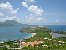
Southeast Peninsula is a peninsula at the southeast end of the island of St. Kitts in the island state of St. Kitts and Nevis , in the Lesser Antilles in the Caribbean .
geography
The Southeast Peninsula forms the “pan handle” of the island in a south-easterly direction, towards the inlet The Narrows . The headland begins immediately southeast of the main town Basseterre and extends for about 14 kilometers towards Nevis . It is connected to the rest of the island by an isthmus that is less than a kilometer wide at its narrowest point. This place is also subdivided by swamps and salt ponds.
The headland is currently the focus of construction projects, as it had hardly been developed for tourism until then. The area is structured by several hills, remnants of the volcanoes that created the Caribbean islands: the northernmost of these, following Frigate Bay, is Sir Timothy's Hill and St. Anthony's Peak . The next one is at Salt Pond Estate and the headlands on the south coast, where the "pan handle" widens again to a wider "handle", are the remains of volcanic activity: Nag's Head , Scotch Bonnet Cape and Majors Bluff . There are also numerous salt ponds and swamps to be found in this part of the country, including the Great Salt Pond , the largest lake in the country. There are numerous bays and beaches: Turtle Beach , Ballast Bay , Major's Bay, and Cockleshell Bay .
Only in the 1990s was the bush-lined area opened up by a road. Since then, a number of hotel buildings have been built, especially at Turtle Beach.
Individual evidence
Web links
Coordinates: 17 ° 14 ′ 1.6 ″ N , 62 ° 38 ′ 32.4 ″ W.
