
Flushing ditch (rocker)
| Flushing ditch | ||
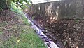
 The rinsing ditch in Wollersleben, Dorfstrasse |
||
| Data | ||
| location | City of Bleicherode , OT Wollersleben , Nordhausen district , Thuringia , Germany | |
| River system | Elbe | |
| Drain over | Mühlgraben → Wipper → Unstrut → Saale → Elbe → North Sea | |
| source | north of Wollersleben 51 ° 26 ′ 39 ″ N , 10 ° 43 ′ 24 ″ E |
|
| muzzle | southeast of Wollersleben in the Mühlgraben, later in the Wipper coordinates: 51 ° 26 '14 " N , 10 ° 43' 15" E 51 ° 26 '14 " N , 10 ° 43' 15" E
|
|
| length | 0.8 km; from the junction with Mühlgraben about 1.5 km | |
| Small towns | Bleicherode | |
The Spülgraben is about 800 m long, left tributary of the Mühlgraben and thus indirectly the Wipper in Wollersleben , a district of the town of Bleicherode in the northern Thuringian district of Nordhausen .
course
The small stream rises north of Wollersleben. It flows through a deep and densely wooded ditch from its source to the underpass of the Nordhausen - Leinefelde railway line . After the underpass it flows through Wollersleben from north to south, but turns for a few meters in an easterly direction. After it has left the village, it flows into the Mühlgraben and, a little further down the stream, it joins the Unstrut tributary Wipper.
Others
In periods of the year with little rainfall, it happens that the bed of the small brook falls dry. The Mühlgraben has not been fed by Wipper water for decades. The amount of water supplied to the Mühlgraben (via rinsing ditch) is missing. Thus Mühlgraben comes to a standstill and resembles a pond.
photos

Rinsing ditch in Wollersleben
Rinsing ditch in Wollersleben

Rinsing ditch in Wollersleben


Web links
Individual evidence
- ↑ Map from Google Earth