Spanish Virgin Islands
| Spanish Virgin Islands | ||
|---|---|---|
| Waters | Caribbean Sea | |
| archipelago | Virgin Islands | |
| Geographical location | 18 ° 14 ′ N , 65 ° 20 ′ W | |
|
|
||
| Number of islands | 2 + minor islands | |
| Main island | Vieques and Culebra | |
| Total land area | 165.1 km² | |
| Residents | 11,119 (2010) | |
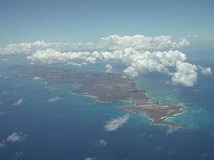
| Aerial view of the largest Spanish Virgin Island, Vieques | ||

The Spanish Virgin Islands , also known as the Puerto Rican Virgin Islands and formerly the Passage Islands , are a group of islands east of the island of Puerto Rico . They consist of the main islands of Culebra and Vieques as well as a number of small side islands.
Surname
At least since the beginning of permanent settlement by Spain in the 1810s, the German name as Spanish Virgin Islands has also been used.
Because of their affiliation with Puerto Rico , the islands are also known as the Puerto Rican Virgin Islands . The Spanish Virgin Islands were formerly known as the Passage Islands because of their location west of the Virgin Passage (the archipelago's other archipelagos, the US Virgin Islands and the British Virgin Islands , are entirely east of the Passage) .
geography
The archipelago consists of the main islands Vieques and Culebra as well as various smaller secondary islands . These include the islands: Icacos Island , Cayo Lobo , Cayo Diablo , Palomino Island , Palominito Island , Isla de Ramos , Isla Pineiro , Cayo Lobo and Cayo de Luis Pena . All islands of the Spanish Virgin Islands have an area of 165.1 km². The Spanish Virgin Islands, together with the American Virgin Islands and the British Virgin Islands, form the island group of the Virgin Islands .
population
According to the 2010 census, there are 11,119 inhabitants on the Spanish Virgin Islands. Compared to the previous census of 2000, the population increased by 143 in ten years (2000: 10,974 inhabitants). The largest settlement on the islands, with 1,459 inhabitants, is Isabelle Segunda , the capital of the island and also the municipality of Vieques.
politics
The Spanish Virgin Islands belong to the US American suburb of Puerto Rico and are therefore also part of the United States of America .
In terms of its political structure, the Spanish Virgin Islands do not represent a separate local authority. They are divided into the two municipalities of Culebra and Vieques and thus represent 2 of the 78 municipalities in Puerto Rico. Each of the municipalities is headed by a mayor and municipal legislature, who are elected every four years.
The municipalities are further subdivided into a total of 14 districts ( Spanish barrio s).
| No. | district | local community | Population (2010 census) |
Population (2000 census) |
Area [km²] |
Population density 2010 [people / km²] |
Associated islands |
|---|---|---|---|---|---|---|---|
| 1 | Culebra barrio-pueblo | Culebra | 462 | 652 | 1,594.3 | 0.409 | - |
| 2 | flamenco | Culebra | 1,048 | 885 | 70.2 | 12,600 | Cayo Pirata, Cayo Verde, Cayo Matojo, El Ancon, Piedra Stevens, Los Gemelos, Alcarraza, Roca Lavador (flooded), Cayo Botijuela, Cayo de Luis Peña, Las Hermanas (Cayo del Agua, Cayo Ratón, Cayo Yerba), El Mono , Cayo Lobo, Roca Culumna (part of Cayo Lobito), Cayo Lobito, Cayo Tuna |
| 3 | Fraile | Culebra | 42 | 51 | 6.2 | 8.212 | Culebrita , Cayo Botella, Pelá, Pelaita |
| 4th | Playa Sardinas I | Culebra | 186 | 136 | 331.5 | 0.412 | - |
| 5 | Playa Sardinas II | Culebra | 64 | 122 | 46.9 | 2,600 | - |
| 6th | San Isidro | Culebra | 16 | 22nd | 3.8 | 5,858 | Roca Bacon, Cayo Norte, Cayo Sombrerito, Cayos Geniquí, Cayo Tiburón, Cayo Ballena |
| 7th | Isabela II barrio-pueblo | Vieques | 1,207 | 1,459 | 2,093.3 | 0.697 | - |
| 8th | Florida | Vieques | 3.821 | 4.126 | 357.1 | 11,554 | - |
| 9 | Llave | Vieques | 18th | 8th | 0.5 | 15,421 | - |
| 10 | Mosquito | Vieques | 0 | 0 | 0.0 | 6.279 | - |
| 11 | Puerto Diablo | Vieques | 1,896 | 984 | 21.7 | 45.324 | Roca Cucaracha, Isla Yallis, Roca Alcatraz, Cayo Conejo, Cayo Jalovita, Cayo Jalova |
| 12 | Puerto Ferro | Vieques | 705 | 856 | 40.4 | 21,200 | Isla Chiva, Cayo Chiva |
| 13 | Puerto Real | Vieques | 1,654 | 1,673 | 83.9 | 19,944 | Cayo de Tierra, Cayo de Afuera (Cayo Real) |
| 14th | Punta Arenas | Vieques | 0 | 0 | 0.0 | 11.227 | - |
| total | 11,119 | 10,974 | 67.9 | 161.737 | |||
history
Occasionally you can read that Christopher Columbus discovered the Spanish Virgin Islands in 1493 on his second trip to America, during which he also landed in neighboring Puerto Rico. However, it is not certain that Columbus actually docked on one of the Spanish Virgin Islands. Shortly after Columbus took possession of Puerto Rico for Spain in 1493, Spain also claimed the Spanish Virgin Islands for itself. For a long time Spain did not undertake permanent settlement.
For around 300 years, the islands were a lawless outpost and retreat for smugglers and pirates . Other European powers temporarily took control of some of the islands. For example, Vieques was controlled by Brandenburg-Prussia from 1689 to 1693 under the name of Krabbeninsel and briefly went to Scotland in 1698 , before it was temporarily controlled by Denmark shortly afterwards .
It was not until the beginning of the 19th century that Spain began to settle the islands permanently. In 1811, the then governor of Puerto Rico, Don Salvador Meléndez, sent troops to secure the islands for Spain under administrative management from Puerto Rico.
Since this time at the latest, the islands have been known in German as "Spanish Virgin Islands".
In 1898 the USA occupied Puerto Rico in the course of the Spanish-American War and together with it claimed the neighboring Spanish Virgin Islands for themselves.
Individual evidence
- ↑ Johann Georg August Galletti's: Allgemeine Weltkunde, or Encyclopedia for Geography, Statistics and State History: An aid when studying daily history for thinking and educated readers . Ed .: Hugo Franz Ritter von Brachelli. Hartleben, 1859 ( google.de [accessed on February 23, 2018]).
- ↑ a b Textbook of geography according to the latest peace regulations. 4th ed. 2nd part . 1818 ( google.de [accessed on February 23, 2018]).
- ↑ a b c U.S. Census Bureau: American FactFinder - Results Municipality of Vieques 2010 . Retrieved February 27, 2018 .
- ↑ a b U.S. Census Bureau: American FactFinder - Results Culebra Community 2010 . Retrieved February 27, 2018 .
- ↑ a b U.S. Census Bureau: American FactFinder - Results Municipality of Vieques 2000 . Retrieved February 27, 2018 .
- ↑ a b U.S. Census Bureau: American FactFinder - Results Culebra Community 2000 . Retrieved February 27, 2018 .


