
Lock point Mülenen


The Mülenen barrier was a defensive position for the Swiss Army . It is located in the village of Mülenen on the Lötschberg line in the Kandertal in the Bernese Oberland . The barrier was built in 1941/42 and belonged to the operational area of the 3rd Division and, from 1947, of the Reduit Brigade 21 . It is considered a military historical monument of regional importance.
history


In the 13th century, the access to the Kandertal was fortified with a castle and a Letzimauer . The impetus for the construction of the plant was given by the new army position in the Reduit ordered by General Guisan (Operation Orders No. 11, 12, 13). The 3rd Division (Bern Division) was withdrawn from the Limmat position and moved from the Fricktal to the new operational area on both sides of Lake Thun.
The Mülenen blocking point served as the third line to block the Kandertal and the Lötschberg line. Behind the barrier were important supply facilities for the Swiss Army such as the army pharmacy in Kandersteg, ammunition and food stores, the war command post of the 3rd Division in Kien, the command post of the 1st Army Corps and, from 1947, the Reduit Brigade 21 in Frutigen.
The terrain armor obstacle (GPH) consisted of a six-row hump barrier , street barricades, walls and prepared blasting or flooding. The Suldbach , which was straightened in 1867 , was expanded as a tank barrier to a concrete tub 14.5 meters wide and 3.5 meters deep. On the enemy side there were infantry obstacles, mines and booby traps. A six-row hump barrier (Tobleron pyramids) and barbed wire barriers were built on the bank into the valley, the passages of which could be barricaded for local traffic with pieces of railroad tracks (plug-in barricades) in concrete brackets. Blasting chambers were prepared to interrupt the Lötschbergbahn by immediately destroying the tracks and were loaded by a mine detachment of the blocking troops. The passage under the railway line would have been blocked with a local flood.
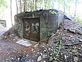
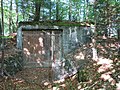
The terrain armored obstacle was created by the Suldschlucht infantry plant (army designation A 1975), the Niesen / Kander infantry bunker as a counter-work (A 1978), the Bergfuss infantry bunker (A 1976) and the central ruined infantry bunker (A 1977) on the former castle hill (today in Chalet- Integrated new building). The infantry work was a rock work armed with a 7.5 cm bunker cannon, 2 machine guns and an infantry cannon and had space for a train of occupiers. The Kander / Niesen infantry bunker was armed with infantry and anti-tank guns and had half-platoon accommodation behind the fighting post. His weapons were aimed at the hump lock and the notch front of the Suldschlucht infantry factory.
- Suldschlucht Infantry Plant A 1975 ⊙
- Bergfuss A 1976 infantry bunker ⊙
- Infantry bunker ruin A 1977 ⊙
- Infantry bunker Kander / Niesen A 1978 ⊙

Bergfuss A Infantry Bunker 1976

Infantry bunker ruin A 1977

Infantry bunker Kander / Niesen A 1978


Artillery position in Mülenen
The Mülenen artillery position (army designation “Mühle” A 1970–1972 / “Mühle AG” A 1973) is located on the edge of the forest in the Schützenweid, directly at the Mülenen barrier. The position belonged to the operational area of the 3rd Division and from 1947 to the Reduit Brigade 21. The position was handed over to the troops in 1942 and was no longer used from 1947.
By order of March 1941, the 3rd Division formed the division artillery groups (Div Art Gr) I on the right and II on the left bank of Lake Thun. The firing positions of Division Artillery Group II were in the Faulensee-Krattigen-Reichenbach-Aeschi-Hondrich area. The command post Heinrich (KP Heinrich) was the central fire coordination / fire control center with command and observation posts for the artillery works around Lake Thun.
In 1941 the loan application for the artillery position "Mühle" was approved by the 3rd Division. Concrete positions for a mobile 10.5 cm battery as extensive artillery support were built at the Mülenen barrier. Immediately on the edge of the forest behind the Suldbach, which was concreted out as a tank barrier, three light shelters were used as artillery shields (A 1970–1972) and in front of the barrier a bunker disguised as a barn for the directional / command / work gun (A 1973, now privately used and converted). The guns could be retracted from behind through the wooden gates. For this purpose, a shelter cavern (A 1974) for crew and ammunition was built on the slope behind the signs.
The armouring consisted of four mobile 10.5 cm cannons 35 on field mounts , one of them as a lead gun.
The observation post belonging to the battery was on the Niesen slope (Huttenweid, point 1156). The system was operated from 1941 by the heavy motor cannon battery (Sch Mot Kan Bttr) 105 of the heavy motor cannon department 3. From 1947 the artillery position was no longer used.
- Splinter protection shield Artillery A 1970 ⊙
- Splinter protection shield Artillery A 1971 ⊙
- Splinter protection shield Artillery A 1972 ⊙
- Artillery bunker «Milchpintli» A 1973, work gun ⊙
- Ammunition shelter / cavern A 1974 ⊙
- Battery observation post, not implemented or only implemented in the field ⊙

Artillery shield A 1970

Artillery shield A 1971
Artillery shield A 1972

Artillery shield "Milchpintli" A 1973
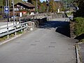
Plug-in barricade at the train station


- Ammunition magazine B 0844 ⊙
- Ammunition magazine B 0847 ⊙
- Ammunition magazine B 0846 ⊙
- Ammunition magazine B 0848 ⊙
- Nomad house B 8585 ⊙
- Underground ammunition magazine AXXXX ⊙
The Swiss Army (armasuisse) wants to demolish the three artillery shields (A 1970, 1971, 1972), four ammunition storage buildings in the Suldgraben and the barricade depot "Nomadenhaus" (November 2015), which means that another piece of Reduit will disappear.
Artillery position Heustrich

With the four artillery shields Heustrich (army designation "Strick" A 1960–1963), permanent bunkered positions were created for the mobile artillery. The system was operated by the heavy motor cannon battery (Sch Mot Kan Bttr) 106 of Artillery Department 3 of the 3rd Division, which had its command post in KP Heinrich .
The four gun bunkers with two shelters (A 1964, A 1965) are located at the foot of the Niesen in front of the Heustrich-Emdtal train station, which has now been demolished . Construction began in July 1942. To do this, the road from Heustrich to Mülenen had to be lengthened 200 meters and the bridge reinforced. In June 1944 the bunkered position was handed over to the troops. The armament consisted of four 10.5 cm cannons on field mounts, which could only be used artillery in these positions.
- Artillery shield A 1960 ⊙
- Artillery shield A 1961 ⊙
- Artillery shield A 1962 ⊙
- Artillery shield A 1963 ⊙
Artillery shield A 1961

Artillery shield A 1961 Scharte


literature
- Hans-Rudolf Schoch: The heavy motor cannon units : In: Das Artilleriewerk Krattigen A1952 . Frutigen 2015.
Web links
- Oberland Fortress: Mülenen BE
- Fortress Oberland: Artillery shields Mülenen A 1970-73
- Fortress Oberland: Artillery shields Heustrich A 1960-63
- Lock Mülenen in Kandertal
- Canton of Bern: dam from World War II - modern successor to the medieval Letzi von Mülenen, municipality of Reichenbach in the Kandertal
- Lock Mülenen: Bunker A 1978 Kander
Individual evidence
- ^ Military monuments in the cantons of Bern and Friborg. VBS, Bern 2006 ( Memento from September 23, 2015 in the Internet Archive )
- ↑ Oberland Fortress: Lock Mülenen
- ^ Canton of Bern: dam of the 2nd World War - modern successor to the medieval Letzi von Mülenen
- ^ Fortress Oberland: Video IW Suldschlucht A 1975
- ^ Fortress Oberland: Artillery shields Mülenen
- ↑ Berner Zeitung of November 21, 2015, Hans Rudolf Schneider: A piece of Reduit disappears
- ^ HS publications: publishing house for publications on Swiss fortifications, bunkers and fortresses, Frutigen
Coordinates: 46 ° 38 '20.5 " N , 7 ° 41' 31.9" E ; CH1903: 619,414 / 165340