Spokane Valley
| Spokane Valley | |
|---|---|
|
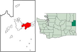
Location in the county and county in the state
|
|
| Basic data | |
| Foundation : | 2003 |
| State : | United States |
| State : | Washington |
| County : | Spokane County |
| Coordinates : | 47 ° 40 ′ N , 117 ° 14 ′ W |
| Time zone : | UTC-8, in summer UTC-7 |
| Residents : | 89,440 (as of: 2009 estimate) |
| Postal code : | 99206 |
| Area code : | +1 509 |
| GNIS ID : | 1967430 |
| Website : | www.spokanevalley.org |
| Mayor : | Richard Munson |
Spokane Valley is a municipality in the US state of Washington .
Spokane Valley is located in Spokane County on the Spokane River . The name is based on the Indian tribe of Spokan which populated the area until the arrival of the Europeans.
To the west of Spokane Valley is the somewhat larger county capital Spokane , to the east is Liberty Lake . To the northeast, the small community of Millwood is enclosed on three sides by the Spokane Valley.
history
The Spokane valley was inhabited by an Indian tribe of the inland Salish , who were called Spokane by the whites from the late 18th century onwards.
In 1849 the first white settler Antoine Plante built a hut in what is now the city. Even before the founding of today's larger neighboring city of Spokane, the first shop and the first ferry of the whites on Spokane were built in today's Spokane Valley area in 1850, the first shop in 1862, the first bridge in 1864, the first house in 1866 and the first post office in 1867.
The Indians were defeated militarily in 1858 and then deported to reservations. The influx of white settlers was increased by the connection to the Northern Pacific Railway in 1883.
Between 1900 and 1922 the population increased from 1000 to 10,000 due to extensive farmland development using irrigation techniques. In 1920 the local newspaper Spokane Valley Herald was founded. Some factories were built in the 1940s.
The Spokane Valley Ward was formed on March 31, 2003 through the amalgamation of Dishman, Green Acres, Opportunity, Trentwood, Veradale, Yardley and parts of Chester and Otis Orchards parishes, also incorporating previously unincorporated areas between these parishes. Four referendums on the union had previously failed. With a population of 89,440 ( Washington State Office of Financial Management estimate , April 2009), Spokane Valley is the second largest city in the east of the state after Spokane and the seventh largest overall.
Individual evidence
- ^ History of the Spokane Valley . In: Spokane.net . Archived from the original on December 2, 2009. Info: The archive link was automatically inserted and not yet checked. Please check the original and archive link according to the instructions and then remove this notice. Retrieved July 12, 2009.
- ↑ Spokane Valley Demographics ( Memento of the original from July 27, 2009 in the Internet Archive ) Info: The archive link was inserted automatically and has not yet been checked. Please check the original and archive link according to the instructions and then remove this notice. Retrieved August 21, 2009
