Springfield (Georgia)
| Springfield | |
|---|---|
|
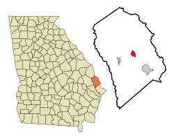
Springfield in Effingham County
|
|
| Basic data | |
| State : | United States |
| State : | Georgia |
| County : | Effingham County |
| Coordinates : | 32 ° 22 ′ N , 81 ° 19 ′ W |
| Time zone : | Eastern ( UTC − 5 / −4 ) |
| Residents : | 2,520 (as of 2010) |
| Population density : | 466.7 inhabitants per km 2 |
| Area : | 5.4 km 2 (approx. 2 mi 2 ) of which 5.4 km 2 (approx. 2 mi 2 ) is land |
| Height : | 24 m |
| Postal code : | 31329 |
| Area code : | +1 912 |
| FIPS : | 13-72780 |
| GNIS ID : | 0333107 |
| Website : | www.cityofspringfield.com |
Springfield is a city with a status of " City " and a county seat of Effingham County in the US state of Georgia . In 2010 Springfield had 2520 residents.
geography
The coordinates of Springfield are 32 ° 22'6 "north latitude and 81 ° 18'37" west longitude. According to the 2010 United States Census , the urban area of Springfield covers an area of 5.4 square kilometers (2.1 sq mi).
population
According to the 2010 United States Census , Springfield had 1,529 people in 575 households and 423 families. The population density was 466.7 people per square kilometer.
The population in 2000 was composed of 76.28% White, 22.13% African American, 0.05% Asian, 0.11% Native American, 0.77% from other races, and 0.27% from two or more races from. Of the 1821 inhabitants at that time, 24.1% were under 18 years of age and people 65 years or older lived in 17.1% of the households. The median age was 36 years.
