
Sreng (river)
| Sreng | ||
 |
||
| Data | ||
| location | Cambodia | |
| River system | Mekong | |
| Drain over | Sangke → Tonle Sap → Mekong → South China Sea | |
| source |
Dongrek Mountains 14 ° 19 ′ 40 ″ N , 104 ° 29 ′ 10 ″ E |
|
| muzzle |
Sangke coordinates: 13 ° 20 '53 " N , 103 ° 27' 31" O 13 ° 20 '53 " N , 103 ° 27' 31" O |
|
| Mouth height |
5 m
|
|
| Catchment area | 4504 km² | |

The Sreng ( Stung Sreng , also written Stoĕng Sreng ) is a river in northwest Cambodia . It rises in the hills of the Dongrek Mountains in the province of Oddar Meanchey , flows through Anlong Veng , forms the border with the province of Siem Reap after the small lake southeast of the district capital of the same name and from Khnang the border between the provinces of Siem Reap and Banteay Meanchey , before it flows into the Tonle Sap tributary Sangke near Peam Saima on the border with Battambang province . With 9,471 km² it has the second largest catchment area of the rivers around the Tonle Sap Lake , which has an annual rainfall of approx. 1,500 mm. The average flow rate of the river is estimated at 9,732 m³ / s. It is not navigable because it dries out in the dry season and its flow rate is too high in the rainy season. The main tributaries of the Sreng are the Srang (also spelled Srong ), the Tanat , the Ta Thlok and the Phlang .
The river is part of the Stung Sreng Water Resource Development Project . As soon as it is completed, 25,000 hectares of agricultural land will be available in the rainy season and 3,750 hectares in the dry season in the districts of Chongkal (Oddar Meanchey Province), Srey Snom (Siem Reap Province) and Phnom Srok (Banteay Meanchey Province) as well as clean water, in addition, flooding is reduced.

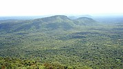
Silhouette of the Dongrek Mountains, headwaters of the Sreng , as seen from Cambodia
The Dongrek Mountains as seen from Thailand


Individual evidence
- ↑ Stung Sreng sub-basin: Rivers and Irrigation ( Memento of October 7, 2007 in the Internet Archive ). Asian Development Bank (PDF; 3.5 kB).
- ↑ Stung Sreng. GeoNames .
- ^ State of water environmental issues. Cambodia. Water Environment Partnership in Asia (WEPA), Ministry of the Environment of Japan.
- ^ The Mekong River System (Basin) in Cambodia ( Memento from July 22, 2011 in the Internet Archive ). Ministry of Public Works and Transport, Cambodia Inland Waterway Navigation, January 31, 2010.
- ↑ C. Nika: Stung Sreng Water Resource Development Project-Phase I. Completed 99% ( Memento from January 1, 2018 in the Internet Archive ). In: Agence Kampuchea Presse. July 11, 2014.