
City wall of Colonia Ulpia Traiana


The city wall of Colonia Ulpia Traiana encompassed the Roman city of Colonia Ulpia Traiana , which was located in the area of today's Xanten in North Rhine-Westphalia . The city wall system was built around 105 AD. It was less used for defensive purposes, but rather a symbol of Roman power and culture on the Roman provincial border with " Free Germania ".
description
The Colonia was on the west bank of the Rhine within the Roman province of Lower Germany . The river formed the border to the "Free Germania". The city wall led around the city in an almost right-angled shape and was 3.4 kilometers long. It enclosed the 73 hectare settlement in which about 10,000 people lived. The wall had 22 towers and three representative gate systems.

Dendrochronological examinations of found wood material in the wall area showed that the trees used were felled in AD 105. Since other sections of the wall may be completed later, no precise statements can be made about the construction time and the time of completion.
The construction of the city wall was the largest construction project in the emerging Colonia that required a considerable logistical effort. Since there were no exploitable natural stone deposits in the area, the stones needed had to be brought by water over long distances. The tuff stone of the wall came from the Brohl valley in the Eifel , around 200 km up the Rhine . It is believed that the Roman military was responsible not only for quarrying and transporting stone, but also for planning and building the city wall.
As a result of the stone robbery during the Middle Ages and in modern times , the stones of the city wall and some of the foundations disappeared, so that no building remains were visible above ground. Only systematic excavations from the 19th century, which have continued in the 1930s, 1950s and 1960s until today, provided information about the structure of the facility.
Wall

The wall was six meters high. In places it had a battlement or was supported on the city side by heaped earth. The wall was crowned by battlements that were far apart. This enabled a legionnaire to throw his lance or pilum at attackers.
The building probably consisted of an outer, masonry and visible shell made of tuff, which was filled with a mixture of lime mortar and rubble stones, known as Roman concrete . The foundation thickness ranged from 1.8 to 3.5 meters. The wall had different construction methods and designs, which among other things was dependent on the building site, the respective construction team or possibly delays in the delivery of materials. In the north-eastern area near the river, the city wall was founded on post gratings made of oak piles because of the soft subsoil . After the wall was erected, a system of ditches was created outside as an approach barrier, which consisted of a pointed ditch and, in some places, a double ditch. The trench system had an inconsistent structure, which is attributed to the different topography and soil conditions.
Towers and gates
The 22 wall towers stood at the end points of streets. It is not known whether they were also used as gate systems. Some towers are supposed to function as gate towers , especially in the port area on the Rhine. The three representative multi-tower gates are the Maas Gate in the south, the Burginatium Gate in the northwest and the Vetera Gate in the southeast. The gate systems were on main roads.
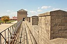
Walkable section of the city wall with battlements and battlements

Inside of the wall filled with earth

The reconstructed gate system of the Burginatium gate (north gate)

The pier tower as a wall tower with a gate

Reconstructed port gate as a tower system

Replica of the city wall through a hedge


reconstruction

In the Xanten Archaeological Park (APX), nine towers, some sections of the wall and the large north gate have been reconstructed by 2018. Longer sections of the earlier wall are reproduced by hedges several meters high. In some places, reconstructed wall sections are accessible to visitors, as are reconstructed wall towers. Around 2018, a new section of the wall was built on one side next to the entrance in the south-western area near the old town of Xanten. It is planned to continue the reconstruction of the wall. During the reconstruction, the wall structure with tuff stone and Roman concrete was used in accordance with the current state of research. At a point next to the entrance to the old town, the cross-section of the wall was made visible by leaving a gap open.
literature
- Martin Müller : The city wall of the CUT in: Martin Müller, Hans-Joachim Schalles , Norbert Zieling (ed.): Colonia Ulpia Traiana. Xanten and its surroundings in Roman times (= history of the city of Xanten. Volume 1). Philipp von Zabern, Mainz 2008, ISBN 978-3-8053-3953-7 , pp. 279-290.
Web links
Individual evidence
Coordinates: 51 ° 40 ′ 2.7 ″ N , 6 ° 27 ′ 10.2 ″ E