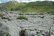
Steinernes Meer (Vorarlberg)
The Vorarlberger Steinerne Meer is an alpine karst plateau in the Lechquellen Mountains on the Formaletsch (2,292 m) near Lech .
The Steinerne Meer is located around two kilometers east of the Formarinsee , in the area of the municipality of Dalaas in the Klostertal , at an altitude between 2050 and 2100 m. The ascent takes place from the Formarinsee or the Freiburger Hütte there or from the Formarinalpe. In the karst of the Formaletsch and Stone Sea there are often fossilized coral sticks , shells of mussels ( megalodonts , cow step clams ), giant clams , tower snails , ammonites and belemnites , which gave the Stone Sea its name.
The rocks of the Stone Sea were deposited about 200 million years ago. A limestone slab made of Upper Rhätkalk with thinly overlying banks of red Lia limestone lies on water- retaining , impermeable Kössen layers and forms a rocky body with multiple holes and fissures. Any meltwater or rainwater disappears in this karstified limestone. There are no surface waters here.
The individual clods of limestone have partially sunk in vertical fissures , which can be seen on the surface through karst alleys and subsidence fields. Both sharp-edged solution forms as well as humps rounded by glacier grinding occur. Stratified stair karst is partially formed in the edge areas . The accessibility of the scenic area is made difficult by a dense network of collapse and dissolving dolines , crevices and cleft carts. The vegetation of the cleft carts mainly consists of different types of ferns ( shield ferns , bladder ferns , striped ferns ).
The Rhine-Danube watershed, which is also the European continental watershed, runs directly in or below this karst plateau of around 1 km² .
Web links
literature
- Dietrich Helmcke: The geology of the Spullersee-Mulde between Wildgruben-Roggalspitz-Gruppe and Formarinsee in the Vorarlberg Limestone Alps. Dissertation, University of Marburg, Marburg an der Lahn 1969
- Max Richter: Vorarlberg Alps. 2. change Edition with 1 geol. Map, Bornträger, Stuttgart / Berlin 1978, Geological Guide Collection (Ed. F. Lotze), Vol. 49
- Arno Bogenrieder , L. Huck, Ekkehard Liehl: Around the Freiburger Hütte. A natural history hiking guide. Schillinger, Freiburg 1984
cards
- Otto Ampferer , Theodor Benzinger, Otto Reithofer: Geological map of the Lechtal Alps 1: 25,000, sheet Klostertal Alps. German and Austrian Alpine Association / Federal Geological Institute, Vienna 1932
- Austrian map 1: 50,000 (ÖK 50): Sheet 142 Schruns. Federal Office for Metrology and Surveying, Vienna 1995
Coordinates: 47 ° 9 ′ 52 ″ N , 10 ° 1 ′ 23 ″ E

