
Steingrundsee
|
Steingrundsee Peterhafen |
||
|---|---|---|

|
||
| Geographical location | Ortenaukreis , Baden-Württemberg , Germany | |
| Places on the shore | Freett | |
| Data | ||
| Coordinates | 48 ° 41 '29 " N , 7 ° 56' 7" E | |
|
||
| Altitude above sea level | 126 m | |
| surface | 70.574 2 ha | |
| length | approx. 1.8 km | |
| width | approx. 440 m | |
| Maximum depth | approx. 10 m | |
|
particularities |
||

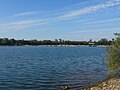
The Steingrundsee , better known as Peter Port is an average of about 440 meters wide and about 1.8 km long quarry pond with an area of 70.5742 hectares in Freistett , the capital city of Rheinau in Baden-Wuerttemberg . The industrial area of Freistett borders the southern shore of the lake.
The Steingrundsee is located in the alluvial forest in the Freistetter Gewann Steingrund, which gave it its name. In the north, the lake is connected to the Rhine via a navigable, 1-kilometer-long canal , which in some places is less than 150 meters from the lake. In the south-west, between the lake and the Rheinau-Gambsheim barrage, is the gravel works of Hermann Peter KG, which is why the lake is also called Peterhafen. The loading station of the gravel works is also located at Steingrundsee, which is why ships cross the lake several times a day. On the south-east bank there is a boat yard as well as a marina.
gallery

Northern part of the Peterhafen
Southern part

