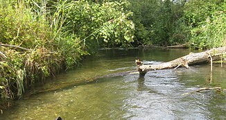
Rhine canal (Ortenau)
|
Rhine side canal Groschenwasser |
||
|
The Rhine canal near Honau |
||
| Data | ||
| Water code | DE : 23532 | |
| location |
Offenburg Rhine plain
|
|
| River system | Rhine | |
| Drain over | Rhine → North Sea | |
| source | Branch of the Rhine side ditch at Auenheim 48 ° 36 ′ 46 ″ N , 7 ° 49 ′ 40 ″ E |
|
| Source height | approx. 131 m above sea level NN | |
| muzzle | At Helmlingen / Freistett in the Rhine Coordinates: 48 ° 42 '21 " N , 7 ° 56' 46" E 48 ° 42 '21 " N , 7 ° 56' 46" E |
|
| Mouth height | approx. 122 m above sea level NN | |
| Height difference | approx. 9 m | |
| Bottom slope | approx. 0.5 ‰ | |
| length | 17.9 km | |
| Left tributaries | Schlute middle distance, Rhine side ditch | |
The Rhine Lateral Canal is a 17.9 km long right tributary of the Rhine in the Ortenau district in Baden-Württemberg . It is often referred to as Groschenwasser , which actually only applies to one section of Freistett . It arises from a branch of the Rhine side ditch near Auenheim and runs almost exclusively through the old Rhine in the north-northeast direction to the port in Freistett . From the port in question to its confluence with the Rhine at Helmlingen and Freistett, its course is largely canalized.
geography
The Rhine side canal begins near the mouth of the Kinzig near Auenheim from a junction from the Rhine side ditch at an altitude of about 131 m above sea level. NN . Initially it flows for approx. 550 m to the east through an arm of the old Rhine until it crosses the connecting canal between the two former quarry ponds, Alter and Neuer Prestelsee . Here it enters another old arm, which even after 1.75 km flows into the old arm of Leutesheim. At the Honau tank farm, the oxbow lake divides, with the Rhine canal following the western branch.
In the vicinity of Honau , the Rhine canal leaves the alluvial forest , while it enters the Altrhein Gießen Honau-Diersheim. After he has passed this and another arm of the Old Rhine, he is canalised for approx. 400 m. Thereupon he enters a rather wide arm of the old Rhine, which he leaves on the east side via a small canal. The canal leads him into the even wider Rheinaue Diersheim, which is followed by the part of the Groschenwasser that has been enlarged to become a quarry pond. Then the Rhine canal flows through the smaller part of the Groschenwasser, which was previously used by Rhine ships.
After the Rhine side canal has crossed the so-called EdF-Straße at the port of Freistett, the Rhine side ditch joins it from the left and it takes on a canalized shape. So it flows first around the port and the Karcher shipyard located there and then past a large weir towards the Rhine to almost the Rhine crossing parallel to the said river. From here it flows canalised at first, but later in a somewhat more natural form past the Peterhafen until a section of the lake is connected to the Rhine canal . This navigable part is the last section before its mouth at a height of 122 m above sea level. NN from the right into the Rhine.
history
During the Second World War, the National Socialists concreted the bank of the Groschenwasser and stationed some old ships there. With this they wanted to achieve that the Allies consider the waters for the Kehler Hafen. Their plan also worked: the alleged port was bombed during air raids.
use
From the Alten Prestelsee in Auenheim until shortly after crossing under the state road 87 in Freistett, the Rhine side canal is a popular paddle destination , but only the relatively small section from the port in Freistett is officially signposted as a paddle route.
Before the construction of the Rheinau-Gambsheim barrage and the resulting increase in the level of the Rhine upstream, the Groschenwasser was still directly connected to the Rhine. The shipping company Ludwig and Jakob Götz from Neckarsteinach took advantage of this and in 1960 turned part of the Groschen water into a quarry pond . In order to be able to load the extracted gravel directly onto ships, they widened the rest of the previously much too small groschen water to approx. 35 m. In 1970 gravel mining was stopped.
gallery
Rhine canal at Peterhafen
Rhine side canal from the connection between Peterhafen and the Rhine
Individual evidence
LUBW
Official online waterway map with a suitable section and the layers used here: Course and catchment area of the Rhine canal
General introduction without default settings and layers: State Institute for the Environment Baden-Württemberg (LUBW) ( notes )
- ↑ a b Height according to the contour line image on the topographic map background layer .
- ↑ Length according to the waterway network layer ( AWGN ) .
Other evidence
- ↑ Heinz Fischer: Geographical Land Survey: The natural spatial units on sheet 169 Rastatt. Federal Institute for Regional Studies, Bad Godesberg 1967. → Online map (PDF; 4.4 MB)


