
Stone box on Visingsö
%27_(11174629956).jpg)
The stone box on Visingsö , a depot for skeletons or human bones, is located west of the F 999 road between Rökinge and Stigby on the island of Visingsö in Vättern in Småland in Sweden . It is believed to have been around 1600 BC. BC, at the end of the Neolithic period .
description

The stone box (Swedish: hällkista) was discovered in 1874 during roadworks near the town of Stora Busarp (which today is part of the Småort Rökinge och Busarp).
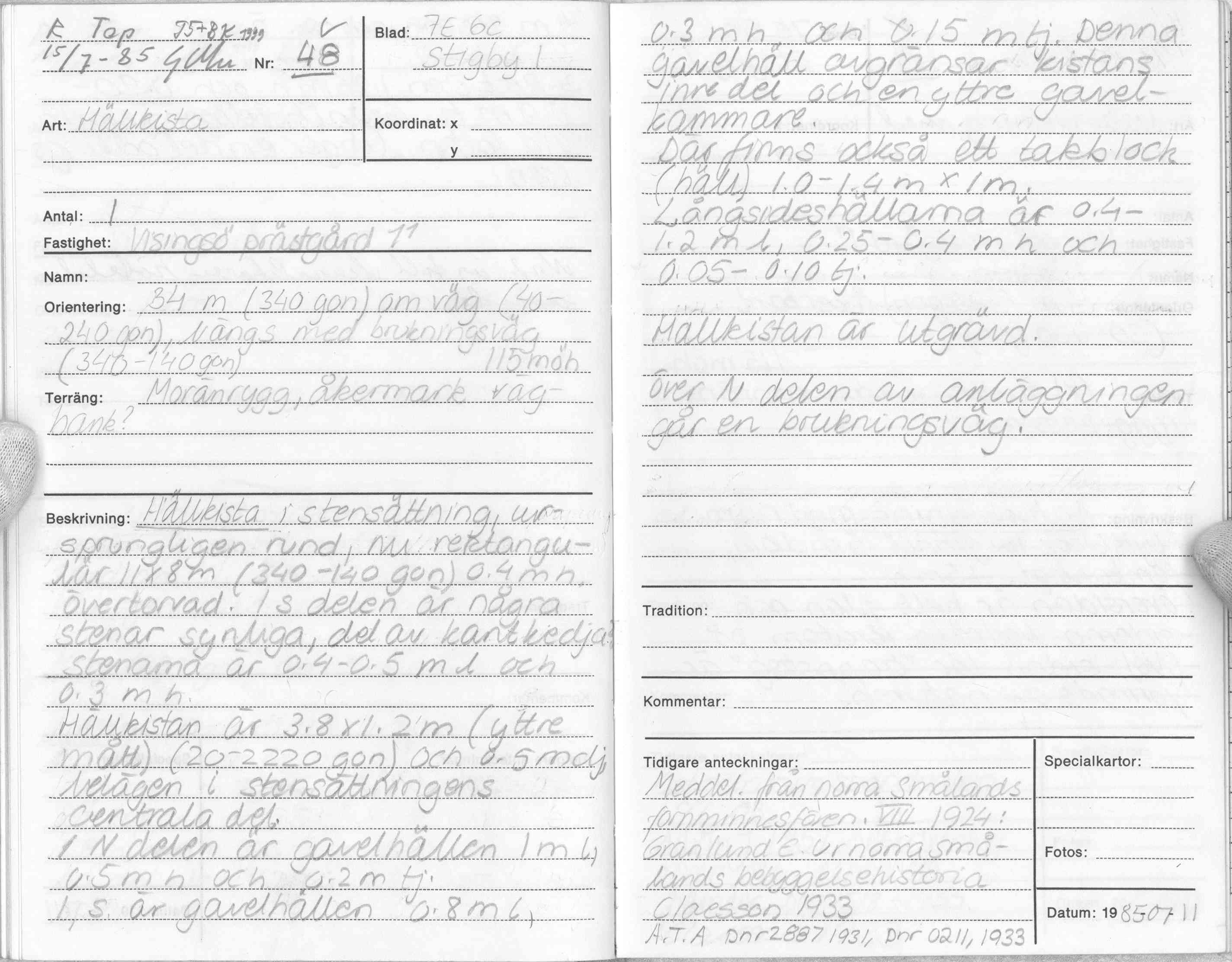
The Swedish archaeologist and historian Wilhelm Berg (1839–1915) examined them after they had been found and made a drawing of the stones that were preserved. It is a capstone and seven bearing stones. In addition, a well-preserved knife made of light gray flint with a square handle was found in the grave about 30 centimeters deep , as well as some smaller unburned bones below. At the southern end there are two more stones that form a corridor . Some coal was found in this corridor. The stone box is almost rectangular in shape, the interior is a good meter wide, the inner length with aisle is almost three and a half meters. The external dimensions given in 1985 for the last inventory were 3.8 meters in length and 1.2 meters in width, the depth is around half a meter, the individual stone slabs are between 5 and 20 centimeters thick. The recessed object has the RAÄ number Visingsö 48: 1.
The stone box is dated to the Neolithic and is considered the oldest permanent find on the island. The stone box has been preserved where it was found. The shifted capstone and the upper parts of the bearing stones have been exposed and are visible. The lower parts are covered with earth.

Stone boxes were collective graves, so the bones may have belonged to several individuals.
When the stone box was built about 3,600 years ago on the central ridge of the island, the water level of Vättern was at least 3.0 m lower than it is today and the island was considerably larger.
The oldest finds from Visingsö are flint axes from 4000–3300 BC. Chr.
Grave fields on Visingsö
About 800 preserved (760 visible) graves on Visingsö are located in three burial fields: the northern, central and southern burial fields. They are located on the ridge that extends over the length of the island and consist of building stones , cathedral rings , burial mounds , ship settlements , stone settlements and Treudds . The southern burial ground is about 700 m south of the stone box, the middle one about 1.5 km north.
See also
literature
- Mårten Stenberger : Nordic prehistory. Volume 4: Prehistory of Sweden. Wachholtz, Neumünster 1977, ISBN 3-529-01805-8 .
Web links
- Stone box on Visingsö - entry in the database "Fornsök" des Riksantikvarieämbetet (Swedish)
- Hällkista, Visingsö (Swedish)
- Gravfälten på Visingsö (Swedish)
Individual evidence
- ^ Wilhelm Berg: Visingsö. Jemte anteckningar om Visingsborgs grefskap . Bonniers, Göteborg 1885, p. 27f. Digitized .
- ↑ entry in Inventeringsbok (inventory book) of the Swedish National Heritage Board , Gert Magnusson, July 15, 1985. Online .
- ↑ Fredrik Engman, Ådel Vestbö-Franzén, Robin Gullbrandsson, Anna Ödéen: Visingsö hamn . Jönköpings läns museum, arkeologisk rapport 2011: 81. Jönköping 2011, p. 6. Online .
- ↑ See, for example, the photos in the blog posts Hällkista, Visingsö or Visingsö är en oförstörd idyll .
Coordinates: 58 ° 1 ′ 44.1 ″ N , 14 ° 19 ′ 22 ″ E