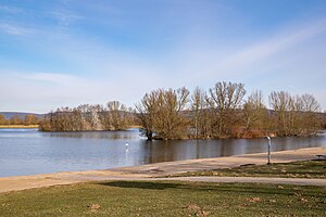
Stemmer lake
| Stemmer lake | ||
|---|---|---|

|
||
| Stemmer See in February 2018 | ||
| Geographical location | Kalletal municipality , Lippe district , North Rhine-Westphalia , Germany | |
| Drain | none | |
| Islands | 2 | |
| Places on the shore | Varenholz , mortising | |
| Location close to the shore | Rinteln , Porta Westfalica , Vlotho | |
| Data | ||
| Coordinates | 52 ° 10 '43 " N , 8 ° 59' 49" E | |
|
|
||
| Altitude above sea level | 49.8 m above sea level NN | |
| surface | 24.7 ha | |
The Stemmer See is a still water between the places Varenholz and Stemmen in the municipality of Kalletal in the North Rhine-Westphalian district of Lippe , but close to the border with the Herford and Minden-Lübbecke districts and also not far from the Lower Saxony border. In 2013 the European Union gave it the rating of “excellent” as a bathing lake. The Weser flows around 350 meters north of the lake. The lake is around 24.7 hectares in size, the shore length is around three kilometers and the water surface is 49.8 m above sea level. NN
Overnight guests at Campingpark Kalletal have access to the lake. Bathers who are not guests of the campsite have only limited access to the Stemmer See.
The Stemmer See has a 600 m long sandy beach and a small bathing island. Offered or possible tourist activities are swimming, snorkeling, diving, surfing and pedal boating. Anglers will also find a worthwhile area here.
