Stetskivka (Sumy)
| Stetskivka (Sumy) | ||
| Стецьківка | ||

|
|
|
| Basic data | ||
|---|---|---|
| Oblast : | Sumy Oblast | |
| Rajon : | Sumy Raion | |
| Height : | 133 m | |
| Area : | Information is missing | |
| Residents : | 3,702 (2001) | |
| Postcodes : | 42303 | |
| Area code : | +380 542 | |
| Geographic location : | 51 ° 1 ' N , 34 ° 47' E | |
| KOATUU : | 5924787101 | |
| Administrative structure : | 5 villages | |
| Address: | вул. Леніна буд. 20 42303 с. Стецьківка |
|
| Website : | City council website | |
| Statistical information | ||
|
|
||
Stezkivka ( Ukrainian Стецьківка ; Russian Стецковка Stezkowka ) is a village in the Ukrainian Sumy Oblast with about 3700 inhabitants (2001).

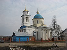
The St. Demetrius Church in Stezkivka , consecrated in 1846
The 1659 by settlers from the right bank Ukraine village founded is the administrative center of the eponymous district municipality in northern Sumy Raion to which even the villages Kardaschiwka ( Кардашівка , ⊙ ) with about 60 inhabitants, Radkiwka ( Радьківка , ⊙ ,) with about 160 inhabitants Rybzi ( Рибці , ⊙ ) with about 100 inhabitants and Shevchenkoe ( Шевченкове , ⊙ ) with about 130 inhabitants.
The village is located 15 km north of the Oblastzentrum Sumy on the trunk road N 07 and on the banks of Oleschnja ( Олешня ), a 40km long, right tributary of the Psel .
Individual evidence
- ↑ Local website on the official website of the Verkhovna Rada ; accessed on December 2, 2017 (Ukrainian)
- ↑ Website to the village on travelua.com.ua ; accessed on December 2, 2017 (Ukrainian)
- ↑ history Stezkiwka in the history of the towns and villages of the Ukrainian SSR ; accessed on December 2, 2017 (Ukrainian)
- ^ Website of the district council on the official website of the Verkhovna Rada; accessed on December 2, 2017 (Ukrainian)

