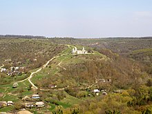
Stina (village)
| Stina | ||
| Стіна | ||

|
|
|
| Basic data | ||
|---|---|---|
| Oblast : | Vinnytsia Oblast | |
| Rajon : | Tomashpil Raion | |
| Height : | 196 m | |
| Area : | 3.89 km² | |
| Residents : | 1,033 (2001) | |
| Population density : | 266 inhabitants per km² | |
| Postcodes : | 24231 | |
| Area code : | +380 4348 | |
| Geographic location : | 48 ° 27 ' N , 28 ° 25' E | |
| KOATUU : | 0523985701 | |
| Administrative structure : | 1 village | |
| Address: | вул. Леніна буд. 20 24231 с. Стіна |
|
| Website : | Official website of the municipal council | |
| Statistical information | ||
|
|
||
Stina ( Ukrainian Стіна ; Russian Стена Stena , Polish Stina ) is a village in the south of the Ukrainian Oblast Vinnytsia with about 1000 inhabitants (2001).
The village, located in the historical region of Podolia , was first mentioned in writing in 1550. The name of the village comes from the high rock walls that surround the village. Stina is the only town in the 3.89 km² district council of the same name in the south of Tomaschpil Rajon .
The village is located at an altitude of 196 m on the banks of the Russava ( Русава ), a 78 km long left tributary of the Dniester , 19 km southwest of the Tomashpil district center and 100 km south of the Vinnytsia oblast center .
The regional road P – 08 runs six kilometers east of the village near Hnatkiw ( Гнатків ) . In the village, on a mountain above the village, is the listed St. Nicholas Church.
Web links
- Ściana . In: Filip Sulimierski, Władysław Walewski (eds.): Słownik geograficzny Królestwa Polskiego i innych krajów słowiańskich . tape 10 : Rukszenice – Sochaczew . Walewskiego, Warsaw 1889, p. 404 (Polish, edu.pl ).
- Municipal Council website on rada.info (Ukrainian)
Individual evidence
- ↑ a b local website on the official website of the Verkhovna Rada ; accessed on June 28, 2020 (Ukrainian)
- ^ Local history of Stina in the history of the cities and villages of the Ukrainian SSR ; accessed on June 28, 2020 (Ukrainian)
- ^ Website of the district council on the official website of the Verkhovna Rada; accessed on June 28, 2020 (Ukrainian)


