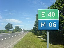
Road system in Ukraine
The road system in Ukraine currently consists of 169,500 kilometers of public roads, 165,500 kilometers of which are paved.
They are divided into:
- Roads of National Importance (дороги державного значення / dorohy derschawnoho snachennja )
- International (long-distance) roads (Міжнародні дороги / Mischnarodni dorohy ): Designation M on a blue background with a two-digit number
- National (long-distance) roads (Національні дороги / Nazionalni dorohy ): Designation Н (Cyrillic N ) on a blue background with a two-digit number
- Regional roads (Регіональні дороги / Rehionalni dorohy ): Designation Р (Cyrillic R ) with a two-digit number
- Territorial roads (Територіальні дороги / Terytorialni dorohy ): Designation T on a blue background with a four-digit number
- Local streets (дороги місцевого значення / dorohy miszewoho snatschennja )
- Oblaststraßen: Designation О with six-digit number
- Rajonsstraßen: no special marking
The roads of national importance are administered by the Державне агентство автомобільних доріг України (Укравтодор / Ukrawtodor - State Road Agency of Ukraine), which reports to the Ukrainian Ministry of Infrastructure.
See also
Web links
Commons : Streets of Ukraine - collection of pictures, videos and audio files
- Website of the State Road Agency of Ukraine - Ukravtodor (Ukrainian)
- Weblog with Ukrainian road traffic topics


