
Subačius
| Subačius | |||
| State : |
|
||
| District : | Panevėžys | ||
| Rajong municipality : | Kupiškis | ||
| Coordinates : | 55 ° 46 ′ N , 24 ° 45 ′ E | ||
| Height : | 75 m | ||
| Area (place) : | 3 km² | ||
| Inhabitants (place) : | 925 (2017) | ||
| Population density : | 308 inhabitants per km² | ||
| Time zone : | EET (UTC + 2) | ||
| Postal code : | LT-40033 | ||
|
|||


Subačius (German, outdated: Subotschen ) is a town in the district of Kupiškis , 14 km southwest of Kupiškis, on the Daugavpils - Panevėžys road ( KK122 ), on the right bank of the Viešinta river . Important sights and facilities are the St. Francis Church , the Subačius grammar school , the library (since 1940) and the post office. The Radviliškis - Daugavpils railway runs through the urban area.
history
The town has its beginnings before the First World War in the territory of the village of Dvariškiai (Kupiškis district), after the railway line Radviliškis - Daugavpils was built in 1873 and the railway station was built.
From 1937 to 1939, priest Povilas Mikalajūnas built the Catholic Church on the Viešinta .
In 1958 Subačius received city rights. During the Soviet era, the local petroleum product warehouse was built - a project that was kept secret at the time and was officially called the " Gintaras Combine" .
Sons of the city
- Virgilijus Alekna (* 1972), discus thrower, Olympic champion
- Romualdas Karazija (* 1942), physicist, professor at the Vilnius Pedagogical University
- Artūras Skardžius (* 1960), manager and politician
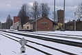
Subačius railway station
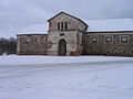
old grain warehouse, of Soviets built

The main street of Subačius is called Biržų Street.

Petroleum product base


