
Sungailiat
| Sungailiat | |||
|---|---|---|---|
|
|||
| Coordinates | 1 ° 51 ′ S , 106 ° 7 ′ E | ||
| Basic data | |||
| Country | Indonesia | ||
| ISO 3166-2 | ID | ||
| surface | 146.6 km² | ||
| Residents | 94,044 (2015) | ||
| density | 641.4 Ew. / km² | ||
| Telephone code | +62717 | ||
 Muhidin Street in downtown Sungailiat
|
|||

Sungailiat (Chinese: 烈 港; Hakka : Lîet-Kóng; formerly: Soengeiliat) is a subdistrict on the island of Bangka in the province of Bangka-Belitung in Indonesia . It is also the capital of the administrative district .
location
Sungailiat is located in the northern third of the east coast of Bangka Island, about 30 kilometers north of Pangkal Pinang, with which it is connected by an asphalt road.
Sungailiat is the second largest settlement on the island, just after the provincial capital Pangkal Pinang. It is the capital of the administrative district, which is divided into 13 districts ( desa or kelurahan ).
economy
,_RP-F-F01183-AQ_Stitch.jpg)
The economy is heavily influenced by the mining and processing of tin , which is abundant in the area's sands. Locals are also involved in fishing and agriculture, growing rubber trees , pepper and, to a lesser extent, palm oil . There are also small companies that process the raw products from these industries into food.
tourism
Tourism is a growing sector, with several Buddhist temples and beaches within the city limits mostly attracting visitors from the rest of the country.
Demographic data
The majority of the people in Muntok are Hakka - Chinese and Malays . The majority of the Chinese are Buddhists, Catholics and Protestants. The Malays are Muslims.
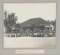
Historical photos
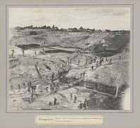
Tin pit
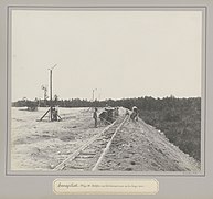
Light rail tracks

Bucket ladder excavator
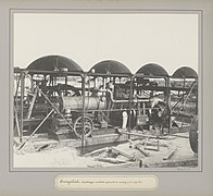
Suction excavator pump
Assembly building

hospital
,_RP-F-F01183-AI.jpg)
,_RP-F-F01183-AB.jpg)
,_RP-F-F01183-AC.jpg)
,_RP-F-F01183-Y.jpg)
,_RP-F-F01183-AF.jpg)
,_RP-F-F01183-X.jpg)
_te_Soengeiliat_Soengeiliat._Mijn_26._Kongsiehuis_met_het_personeel_en_werkvolk_(titel_op_object),_RP-F-F01183-AE.jpg)
,_RP-F-F01183-AD.jpg)
Individual evidence
- ↑ Bangka Regency - Bureau of Statistics ". Badan Pusat Statistics Kabupaten Bangka. Statistics Indonesia. Retrieved August 4, 2017.
- ↑ Statistics Daerah Kecamatan Sungailiat 2016 . Bangka Regency Statistics Bureau. Retrieved August 4, 2017.