Sunkoshi
|
Sunkoshi Sun Kosi, Matsang Tsangpo |
||
|
Sunkoshi above the confluence of the Roshi Khola |
||
| Data | ||
| location | Tibet ( PR China ), Nepal | |
| River system | Ganges | |
| Drain over | Koshi → Ganges → Meghna → Bay of Bengal | |
| Headwaters |
Highlands of Tibet north of the Himalayas 28 ° 27 ′ 24 ″ N , 86 ° 19 ′ 17 ″ E |
|
| Association with |
Arun and Tamor zum Koshi Coordinates: 26 ° 54 ′ 38 " N , 87 ° 9 ′ 42" E, 26 ° 54 ′ 38 " N , 87 ° 9 ′ 42" E
|
|
| length | approx. 430 km | |
| Catchment area | 18,182 km² | |
| Outflow A Eo : 18,182 km² |
MQ Mq |
1100 m³ / s 60.5 l / (s km²) |
| Left tributaries | Tamakoshi , Likhu Khola , Dudhkoshi | |
| Right tributaries | Balephi Khola , Indrawati , Roshi Khola | |
| Small towns | Nyalam , Barhabise | |
| Communities | Dolalghat | |
|
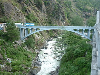
Bridge of Sino-Nepalese friendship between the People's Republic of China and Nepal |
||
|
Sunkoshi in Barhabise |
||
The Sunkoshi (also Sun Kosi ; Nepali सुनकोशी ; Chinese 桑科西 , Pinyin Sāng Kēxī or Matsang Tsangpo ) is a source river of the Koshi in Nepal and in the Tibet Autonomous Region of the People's Republic of China .
The Sunkoshi has its source in Nyalam County in Tibet in the highlands of Tibet north of the Himalayas . It flows in a westerly direction in Tibet, and later it gradually turns to the southwest and south. It passes the administrative center of Nyalam and then cuts through the Himalayan mountain range and reaches Nepal. An important road connecting Tibet and Nepal, the so-called Araniko Highway, runs along the river . The bridge of the Sino-Nepalese friendship spans the river on the state border. After the confluence of the Indrawati from the right, the Sunkoshi turns to the east. It now runs south of the main Himalayan ridge. Finally it unites with the Arun coming from the north and a few hundred meters further downstream with the Tamor coming from the east to form Koshi .
Rafting tours are offered on the river .
At the beginning of August 2014, after intense monsoon rains, a landslide occurred on the course of the Sunkoshi, which resulted in a natural dam. About 30 buildings were buried, a 2 kilometer long lake was created, and the Arniko Highway could no longer be used. The downstream areas were evacuated for fear of uncontrolled breaking of the river barrier.
The upper course of the river above the confluence of the Indrawati is also called Bhotekoshi (not to be confused with the Dudhkoshi tributary of the same name, Bhotekoshi ).
Web links
Individual evidence
- ↑ a b geog.ucsb.edu
- ↑ After landslide in Nepal: Mud lake threatens to bury the valley ( memento from August 2, 2014 in the Internet Archive ) tagesschau.de, August 2, 2014, accessed on August 3, 2014.


