Superstition Mountains
| Superstition Mountains | ||
|---|---|---|
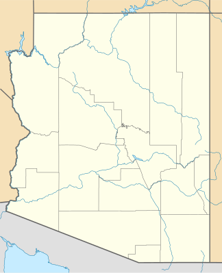
| location | Arizona , United States | |
|
|
||
| Coordinates | 33 ° 29 ′ N , 111 ° 14 ′ W | |
| surface | 718 km² | |
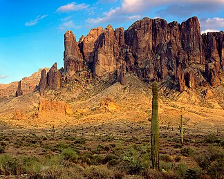
The Superstition Mountains ( Yavapai : Wi: kchsawa , English Superstition = German superstition ) are a mountain range in Arizona in the United States . They are east of the Phoenix metropolitan area and are in the vicinity of Superstition Mountain , a mountain that is a popular recreational destination for the residents of Phoenix .
The Superstition Mountains have a maximum height of 1910 m and a prominence of 520 m at Mound Mountain in the extreme east of the mountains.
In Spanish, the mountains were once under the name Sierra de la espuma known .
traffic
The Superstition Mountains are mostly bounded in the south by US Route 60 , in the northwest by State Route 88 and in the northeast by State Route 188 .
Wilderness Area
The mountains are located in the area designated by the federal government as a Superstition Wilderness Area and, in addition to the eponymous mountain, also include a variety of scenic features such as the Weavers Needle , a striking landmark and climbing destination. It is a highly eroded volcanic remnant and plays an important role in the legend of the Lost Dutchman's Gold Mine .
Climate and tourism
Like much of the landscape around the Phoenix metropolitan area, the Superstition Mountains have a desert climate with high summer temperatures and only a handful of permanent water sources . The altitude in the more remote, eastern part of the mountains is greater than in the western part, which lowers temperatures slightly. Numerous hiking trails traverse the mountains from multiple access points, the most popular being the Peralta Trailhead . The Lost Dutchman State Park , which is located on the west side of the Superstition Mountain, also includes several short hiking trails.
The Peralta Canyon in the northeast and the Miner's Needle , another striking rock formation, are other popular hiking destinations.
Legends


The legend of the Lost Dutchman's Gold Mine revolves around the Superstition Mountains. Legend has it that the German immigrant Jacob Waltz discovered a gold vein in the mountains and revealed its location on his deathbed in Phoenix in 1891 to a pensioner who had looked after him for many years. Several mines have been claimed to be the actual mine that Waltz discovered. But none of these claims have been confirmed. The legends and lore of the Superstition Mountains can be experienced at the Superstition Mountain Museum .
Some Apaches believe that the hole that leads to the lower world or Hell is in the Superstition Mountains. Winds blowing from the hole are believed to be the cause of severe dust storms in the region.
Web links
- Superstition Mountains in the United States Geological Survey's Geographic Names Information System
- Superstition Mountains on Peakbagger.com (English)
- Ajpl.org: History of the Superstition Mountains
Individual evidence
- ^ Mound Mountain, East Superstition Mountains . peakbagger.com. Retrieved September 2, 2016.
- ^ East Superstition Mountains . peakbagger.com. Retrieved September 2, 2016.
- ^ Superstition Mountains Benchmark, Western section . peakbagger.com. Retrieved September 2, 2016.
- ↑ a b Kollenborn, Tom: Weaver's Needle or Picacho? . Archived from the original on October 30, 2004. Retrieved April 1, 2007.
- ↑ Carroll, Doug: Hiking the Supsertitions . Retrieved April 1, 2007.
- ↑ Dave Heim: Superstition Mountain Museum .
- ↑ Vitaliano, Dorothy. 1973. Legends of the Earth , Bloomington: Indiana University Press, pp. 170-171.

