
Tabanan (Administrative Region)
| Kabupaten Tabanan
|
||
|---|---|---|
 |
||
| Symbols | ||
|
||
|
Motto "Sadhu Mawang anuraga" , such as: faithful and wise exercise of faith out of love for the people ' |
||
| Basic data | ||
| Country | Indonesia | |
| Capital | Tabanan | |
| surface | 839.3 km² | |
| founding | 1949 | |
| ISO 3166-2 | ID-BA | |
| Website | www.tabanankab.go.id (Indonesian) | |
| politics | ||
| Bupati | Ni Putu Eka Wiryastuti | |
| Political party | PDI-P | |

Coordinates: 8 ° 32 ' S , 115 ° 7' E
Tabanan is a government district ( Kabupaten ) on the island of Bali , Indonesia . It has an area of 520.81 km² and 197,210 inhabitants (2004). Its seat is the city of the same name Tabanan with 63,479 inhabitants (2015).
geography
Tabanan borders (clockwise from the north) with Buleleng , Badung , the Indic and Jembrana .
It stretches from the coast with important temples such as the Pura Tanah Lot to the Bratan at 2105 m altitude with the Pura Ulun Danu Bratan on Lake Bratan and the botanical garden (Kebun Raya) of the island.
profile
Until 1907 Tabanan was one of the nine kingdoms in Bali at the time. Tabanan is the island's rice chamber and around 73% of the area is made up of rice fields.
administration
The Kabupaten Tabanan consists of 10 Kecamatan , 113 Desa , 729 Banjar adat and 333 Desa adat.
The Kecamatan (corresponds to an integrated community ) are:
- Baturiti = 99.17 km²
- Kediri = 53.60 km²
- Kerambitan = 42.39 km²
- Marga = 44.79 km²
- Penebel = 141.98 km²
- Pupuan = 179.02 km²
- Selemadeg = 57.51 km²
- Selemadeg West = 104.25 km²
- Selemadeg East = 65.22 km²
- Tabanan = 51.40 km²
gallery

Crossing statue of a major crossroads in Tabanan's city center

Main street through Tabanan

typical Warung Babi Guling on the main road Gilimanuk - Denpasar near Tabanan

Batukaru

high-lying rice terraces
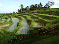
Rice terraces at the Jatiluwih viewpoint

Sea temple at the Bratansee

Field barn in rice terraces


