Tacking Point Lighthouse
| Tacking Point Lighthouse | ||
|---|---|---|
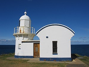
| Tacking Point Lighthouse (2008) | ||
| Place: |
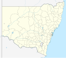
Port Macquarie New South Wales Australia |
|
| Location: | Tacking point | |
| Geographical location: | 31 ° 28 '31.8 " S , 152 ° 56' 13.9" O | |
| Height of tower base: | 26 m | |
| Fire height : | 34 m | |
|
|
||
| Identifier : | Fl (4) W 20s | |
| Scope knows: | 16 nm (29.6 km ) | |
| Optics: | Fresnel | |
| Operating mode: | electric | |
| Function: | Orientation fire | |
| Construction time: | 1879 (automated in 1919) | |
| International ordinal number: | K 2788 | |
Tacking Point Lighthouse is the thirteenth oldest lighthouse in Australia . It was built in 1879 by Shepherd and Joseph William Mortley on the rocky headland of Tacking Point, five miles south of Port Macquarie . The design came from the architect James Barnet . The lighthouse is operated by the Australian Maritime Safety Authority and is classified as a monument by the National Trust of Australia .
The closest lighthouses are Smoky Cape Lighthouse in South West Rocks to the north and Crowdy Head Light to the south.
Management of the lighthouse is shared by three government agencies: the New South Wales Department of Lands owns the lighthouse, Roads and Maritime Services operates the lighthouse, and Port Macquarie-Hastings Council manages the property around the lighthouse.
history
Tacking Point was named by Matthew Flinders in 1802 during his circumnavigation of Australia. He decided not to get any closer to the coast here, turned his ship (English "tacking" = turn ) and named the landmark accordingly.
In the mid-19th century there were few lighthouses in the area and over 20 ships ran aground. The first accident occurred in December 1823 when the schooner Black Jack ran onto the Port Macquarie Reef. As a result, a firm in 1879 mirror lenses - fire with a brightness of less than 1000 cd built on Tacking Point.
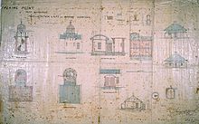
It was the fourth of a total of five lighthouses that were built to a design by James Barnet. The other four were Crowdy Head Light , Fingal Head Light , Richmond River Light, and Clarence River Light (now demolished). Only two of these lighthouses have an attached storage room.
The lighthouse was built from concrete bricks and had to be only eight meters high due to the height of the terrain. In 1919 the luminaire was switched from oil to automatic acetylene operation and automated in 1920, with the foundations of the lighthouse keeper's house still visible today. 1974 was switched to electrical operation.
tourism
A nine-kilometer coastal footpath, built by Port Macquarie-Hastings Council, runs past the lighthouse and goes from Port Macquarie town beach to Lighthouse Beach, southwest of the lighthouse. The area around the lighthouse is a popular place for whale watching . The area is also popular with surfers and there is a Surf Life-Saving Club on neighboring Lighthouse Beach.
Web links
Individual evidence
- ^ Lighthouse Lights - NSW Maritime . In: maritime.nsw.gov.au . Retrieved May 3, 2019.
- ^ Darroch, Donald (2003) East Coast Australia: Sydney to Cairns , Footprint Travel Guides, p. 183
- ^ The Sydney Gazette and New South Wales Advertiser - Classified Advertising - 18 Dec. 1823 Page 3
- ↑ Port Macquarie Info: Tacking Point Lighthouse
- ↑ Tacking Point Lighthouse ( English ) In: New South Wales Lighthouses . Lighthouses of Australia Inc.


