
Taku D Peak
| Taku D Peak | ||
|---|---|---|
 Taku D Peak |
||
| height | 1770 m | |
| location | Alaska | |
| Mountains | Juneau Icefield | |
| Coordinates | 58 ° 42 '29 " N , 134 ° 17' 28" W | |
|
||
| rock | granite | |
| Normal way | Southwest ridge | |

The Taku D Peak is a peak in the 3900 km 2 large Juneau Icefield in Alaska .
location
It is located north of the Alaskan capital Juneau and about 15 kilometers south of the Canadian border. The dividing point is the "Taku D Peak" between the Taku Glacier and the Matthes Glacier .
particularities
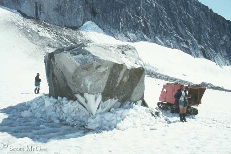
On July 28, 1993, scientists from the JIRP ( Juneau Icefield Research Program ) observed a massive rock fall from the northwest face of Taku D Peak. A massive boulder of this now serves as a reference point for the annual amount of snow on the Juneau Icefield .
Ascents
The first ascent of Taku D Peak was carried out by employees of the Juneau Icefield Research Program for scientific reasons. The ascent route leads over the southwest ridge. The southwest ridge is now classified as the normal route to Taku D Peak.
In 2011 the German-Austrian extreme mountaineer Florian Hill and his team partner the Austrian Max Kirchsasser were able to climb the south-east face for the first time. The ascent was done by fair means and lasted a total of 16 days. The team chose the ascent on skis from Juneau over the Taku Glacier . The descent took place over the Mendenhall Glacier . The difficulty rating is TD-, E5.
Web links
- crevassezone (English) accessed on May 22, 2011
- crevassezone / image
Individual evidence
- ↑ Mountain life : Florian Hill in Alaska: Radical and successful "by fair means" (queried on October 21, 2011)