Talbragar River
| Talbragar River | ||
|
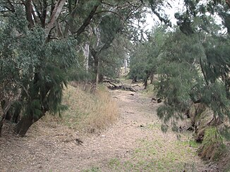
Talbragar River, dried up, near Cobbora |
||
| Data | ||
| location | New South Wales , Australia | |
| River system | Murray River | |
| Drain over | Macquarie River → Barwon River → Darling River → Murray River → Indian Ocean | |
| source | The Pigeon Box Rock, west of the Liverpool Range 31 ° 44 ′ 59 ″ S , 150 ° 5 ′ 54 ″ E |
|
| Source height | 1130 m | |
| muzzle |
Macquarie River near Dubbo Coordinates: 32 ° 11 ′ 19 ″ S , 148 ° 36 ′ 33 ″ E 32 ° 11 ′ 19 ″ S , 148 ° 36 ′ 33 ″ E |
|
| Mouth height | 258 m | |
| Height difference | 872 m | |
| Bottom slope | 3.1 ‰ | |
| length | 277 km | |
| Left tributaries | Tucklan Creek, Sandy Creek, Mullion Creek, Barragonumbel Creek, Mitchells Creek, Plain Creek | |
| Right tributaries | Bounty Creek, Norfolk Island Creek, Turee Creek, Cainbil Creek, Coolaburragundy River , Boomley Creek, Spring Creek, Goan Creek, Jones Creek | |
| Medium-sized cities | Dunedoo, Dubbo | |
| Small towns | Uarbry, Cobbora, Elong Elong, Murembung, Ballimore, Beni | |
The Talbragar River is a river in the middle of the Australian state of New South Wales .
It was first mentioned by European explorers as the Putterbatta River in the 1820s .
course
It rises on the western slopes of the Liverpool Range at Cassilis , flows west and flows into the Macquarie River at Dubbo .
Since the course of the river begins in an area with infrequent rainfall, it is dried out for most of the year (see also Creek ). However, when it rains it swells rapidly and often floods the village of Dubbo.
Tributaries
Its main tributaries are the Coolaburragundy River and the Mitchells Creek . The first bridge over the river was built in the 1850s near Dunedoo on the middle reaches by Thomas New , a settler.
See also
Web links
Commons : Talbragar River - collection of images, videos and audio files
