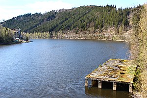
Březová dam
| Březová dam | |||||||
|---|---|---|---|---|---|---|---|
| Březová dam | |||||||
|
|||||||
|
|
|||||||
| Coordinates | 50 ° 11 '51 " N , 12 ° 51' 28" E | ||||||
| Data on the structure | |||||||
| Height of the barrier structure : | 24.95 m | ||||||
| Crown length: | 228.8 m | ||||||
| Crown width: | 8.4 m | ||||||
| Power plant output: | 0.258 MW | ||||||
| Data on the reservoir | |||||||
| Altitude (at congestion destination ) | 430 m nm | ||||||
| Water surface | 76.8 ha | ||||||
| Storage space | 5 687 000 m³ | ||||||
The Březová dam , formerly the Pirkenhammer dam , also known as the Karlsbad dam ( Vodní nádrž Březová in Czech ) is a water reservoir in the Czech Republic . Together with the Stanovice Dam, it serves to protect Karlovy Vary from flooding .
geography
The facility is located four kilometers southwest of the center of Karlovy Vary at 430 m above sea level. M. in the Kaiserwald between the mountains Doubská hora ( Aberg ), Ohreč ( Risswald ) and Vysoký hřbet ( Table Mountain ) in a bend in the Teplá river in the area of the municipality of Březová . The dammed body of water is the Teplá .
The Mariánské Lázně – Karlovy Vary railway runs west of the reservoir . To the east, the E49 / State Road 20 between Karlovy Vary and Mariánské Lázně runs along the dam and over the dam . To the southeast lies the Funkštein castle ruins ( Funkenstein ).
history
After the flood of November 24, 1890 in Karlovy Vary, the city began planning flood protection measures. In 1907, an expert report by the Hydrographic State Office in Prague deemed the construction of two dams on the Teplá and the Lamnitzbach to be necessary. For the purpose of rapid flood protection, the decision was made to initially only build a dam on the Teplá. The dam was to be built in the “Aicher joint” bend in the river. There the subsoil was found to be unsuitable and the preparations for the dam construction were started one kilometer below the originally intended location, where solid granite was located.
The First World War interrupted planning, which was not continued until 1926. Construction work began in July 1931 by a consortium consisting of the Prague-based company Lanna and Pittel + Brausewetter from Vienna, which was completed in October 1935. In 1937 the dam was put into operation. The old stone toll bridge over the Teplá, which becomes visible at low tide, was flooded by the traffic jam.
The 24.95 m high dam lies to the west above the village of Březová. The crest of the dam, which serves as a road, is 228.8 m long and 8.4 m wide. The dam holds 5.687 million m³ of water and has a water surface of 76.8 ha.
A small power plant was set up in the dam . It consists of three units, the first two of which are each equipped with a Francis F30H turbine and can provide a total output of 216 kW. The third unit has an output of 42 kW.

