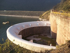
El Cadillal dam
| El Cadillal dam | ||
|---|---|---|
| The inlet of the flood relief | ||
| location | ||
|
|
||
| Coordinates | 26 ° 36 '56 " S , 65 ° 11' 41" W | |
| country |
|
|
| place | Tucuman Province | |
| Waters | Río Salí | |
| Height upstream | 607.5 m | |
| power plant | ||
| owner | Secretaría de Energía de la Nación | |
| operator | Hidroeléctrica Tucumán SA | |
| construction time | 1962 to 1966 | |
| Start of operation | 1966 | |
| technology | ||
| Bottleneck performance | 12 megawatts | |
| Average height of fall |
53.8 m | |
| Expansion flow | 12 m³ / s | |
| Standard work capacity | 52.9 million kWh / year | |
| Turbines | 2 × 6 MW | |
| Others | ||
The El Cadillal dam or the Dr. Celestino Gelsi ( Spanish: Represa El Cadillal or Dique El Cadillal or Represa Dr. Celestino Gelsi ) is a dam with hydropower plant in the province of Tucumán , Argentina . It dams the Río Salí to a reservoir. The dam and the associated hydropower plant are also known as the El Cadillal hydropower plant complex (Spanish Complejo hidroeléctrico El Cadillal ). The provincial capital of San Miguel de Tucumán is around 15 km south of the dam.
The dam is used to generate electricity and supply drinking water. Construction began in 1962. It was completed in December 1965. The dam and the hydroelectric power station are state-owned ( Secretaría de Energía de la Nación ). The concession for the operation was transferred to Hidroeléctrica Tucumán SA on July 3, 1996. The dam was named after a former governor of the Tucumán Province, Celestino Gelsi .
Barrier structure
The barrier structure is an embankment dam with a height of 72 m above the river bed (maximum height 85 m). The crest of the dam is at an altitude of 616 m above sea level . The length of the dam crest is 503 m, its width at the crown 10 m. The volume of the barrier structure is 4.1 (or 4.385) million m³.
The dam has both a flood relief and a bottom outlet . A maximum of 1000 (or 1300 or 1500) m³ / s can be discharged via the flood discharge, and a maximum of 85 m³ / s via the bottom outlet.
Reservoir
The normal storage destination is between 577.5 and 607.5 m. With a storage target of 607.5 m, the reservoir extends over an area of around 10.62 (or 13) km² and holds 217 (or 240 or 300) million m³ of water. The maximum storage destination is 611 m, the minimum 562 m.
power plant
The power plant's machine house is located about 500 m from the dam on the right bank of the river. The installed capacity is 12 (or 13 or 14) MW . The average annual generation is given as 48 (or 52 or 52.9) million kWh . Annual production fluctuates: in 2005 it was 26.34 million kWh and in 2001 it was 63.93 million kWh. The power plant went into operation on August 8, 1966.
The two turbines each produce a maximum of 6 (or 6.86) MW and the generators each 7 MVA . The nominal speed of the turbines is 500 min −1 . The fall height is between 35 and 63.7 m. The flow rate is 12 m³ / s (maximum 12.5, minimum 4.4 m³ / s). In the switchgear , the generator voltage is increased from 13.2 kV to 132 kV using power transformers.
See also
Web links
- CONSTRUCCION DEL DIQUE EL CADILLAL (TUCUMAN). YouTube , October 8, 2015, accessed May 11, 2019 (Spanish).
Individual evidence
- ↑ a b c d e f g h i Inventario de Presas y Centrales Hidroeléctricas de la República Argentina. (PDF) Ministerio de Planificación Federal, Inversión Pública y Servicios, January 1, 2010, pp. 111–127 , accessed on May 11, 2019 (Spanish).
- ↑ a b c d e f g h Complejo hidroeléctrico El Cadillal. (PDF) www.enre.gov.ar, pp. 3–4 , 12, 14–17, 22–23 , accessed on June 1, 2019 (Spanish).
- ↑ a b c d e Dr. Celestino Gelsi. Organismo Regulador de Seguridad de Presas (ORSEP), accessed May 11, 2019 (Spanish).
- ↑ a b c d Ejercicio 1999 Informe anual. (PDF) ORSEP, pp. 41–42 , accessed on June 13, 2019 (Spanish).
- ↑ a b c d e El Cadillal Hydroelectric Power Plant Argentina. Global Energy Observatory, accessed June 13, 2019 .

