Friant dam
| Friant dam | ||
|---|---|---|
| location | ||
|
|
||
| Coordinates | 37 ° 0 '2 " N , 119 ° 42' 26" W | |
| country |
|
|
| place | Fresno and Madera Counties , California | |
| Waters | San Joaquin River | |
| Height upstream | 176 m | |
| power plant | ||
| Start of operation | 1986 | |
| technology | ||
| Bottleneck performance | 25 megawatts | |
| Others | ||
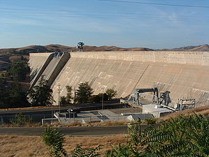
The dam Friant ( English Friant Dam ) is a dam with hydroelectric power plant in the state of California , USA . It dams the San Joaquin River , which at this point forms the border between Fresno and Madera Counties , to a reservoir (English Millerton Lake ). The city of Fresno is about 25 km southeast of the dam.
The dam is primarily used for irrigation and also for flood protection, power generation and drinking water supply. Construction of the dam began in 1939. It was completed in 1942. The dam was built by the United States Bureau of Reclamation (USBR); it is owned by the USBR and is also operated by the USBR. Two irrigation canals go from the dam; the northern Madera Canal and the southern Friant-Kern Canal .
Barrier structure
The barrier structure is a concrete gravity dam with a height of 97 m (319 ft ). The top of the wall is 177 m (581.25 ft) above sea level . The length of the top of the wall is 1063 m (3488 ft). The thickness of the dam is 81.4 m (267 ft) at the base and 6 m (20 ft) at the top. The volume of the concrete used is 1.63 million m³ (2.135 million cubic yards ).
The dam wall has both a flood relief and a bottom outlet . A maximum of 2350 m³ / s (83,000 cft / s) can be discharged via the flood discharge, and a maximum of 464 m³ / s (16,400 cft / s) via the bottom outlet.
Reservoir
With a reservoir target of 176 m (578 ft), the reservoir extends over an area of around 19.46 km² (4810 acres ) and holds 643 million m³ (521,482 acre-feet ) of water. With a maximum storage target of 178.3 m (585 ft), the reservoir extends over an area of around 20.27 km² (5010 acres) and holds 685 million m³ (555,763 acre-feet) of water. The reservoir has a length of around 24 km (15 miles ). The impoundment began on February 21, 1944.
power plant
The installed capacity of the three turbines amounts to a total of 25 (or 30.6) MW . The annual production in 2007 was around 34 million kWh . In the early 1980s, a turbine was installed on each of the two weir systems, from which the Madera Canal and the Friant-Kern Canal branch off. Another turbine uses the water that is directed through the bottom outlet into the San Joaquin River . The turbines went into operation in January 1986.
See also
Web links
- Millerton Lake / Friant Dam Drone Views. YouTube , April 7, 2019, accessed April 21, 2019 .
Individual evidence
- ↑ a b c Friant. United States Bureau of Reclamation (USBR), accessed April 21, 2019 .
- ^ Friant Division Project. USBR, accessed April 21, 2019 .
- ^ Millerton Lake 2004 Survey. (PDF) USBR, March 1, 2007, pp. Iii, 1 , accessed on April 21, 2019 (English).
- ↑ a b FACILITY DESCRIPTIONS AND UPDATED COST ESTIMATES FOR MILLERTON LAKE ENLARGEMENT. (PDF) www.calwater.ca.gov, April 25, 1997, pp. 3, 6 , accessed on April 22, 2019 (English).
- ^ A b Friant Hydro Facility Hydro Power Plant CA USA. Global Energy Observatory, accessed April 22, 2019 .

