
Königshütte dam
| Königshütte dam | |||||||||
|---|---|---|---|---|---|---|---|---|---|
 |
|||||||||
|
|||||||||
|
|||||||||
| Coordinates | 51 ° 44 '19 " N , 10 ° 47' 36" E | ||||||||
| Data on the structure | |||||||||
| Construction time: | 1939-1943, 1952-1956 | ||||||||
| Height above valley floor: | 13 m | ||||||||
| Height above foundation level : | 18.2 m | ||||||||
| Height of the structure crown: | 424.9 m | ||||||||
| Building volume: | 13 500 m³ | ||||||||
| Crown length: | 108 m | ||||||||
| Crown width: | 7 m | ||||||||
| Data on the reservoir | |||||||||
| Altitude (at congestion destination ) | 423.25 m | ||||||||
| Water surface | 32 ha | ||||||||
| Storage space | 1.2 million m³ | ||||||||
| Total storage space : | 1.45 million m³ | ||||||||
| Catchment area | 154.2 km² | ||||||||
| Design flood : | 258.7 m³ / s | ||||||||

The Königshütte dam is a dam in Saxony-Anhalt in the Harz region . It dams the Bode and lies between Königshütte and Susenburg (both districts of Oberharz am Brocken ). As a so-called transfer barrier, it is part of the Rappbode dam system .
description
The dam was built with a war-related interruption from 1939-1943 and 1952-1956 on the Bode as an 18 m high concrete gravity dam for drinking water supply and flood protection, but also serves to increase low water levels and generate electricity. The hydropower plant has a nominal output of 60 kW and generates 0.18 GWh per year.
The slightly curved wall is 108 m long and has a volume of 13,500 m³. You can flow over almost the entire width. A fish-bellied flap is installed in one field , which can be lowered by 1.5 m to relieve the flood .
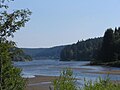
The storage space has a volume of 1.2 million m³ and covers an area of 32 ha. Part of the water is led from here through a 1,795 m long tunnel to the Rappbode dam. The other part flows into the Bode on to the Wendefurth reservoir , where it reunites with the water from the Rappbode reservoir.
A little-used concrete road runs along the north side from Königshütte to the dam. In the embankment walls, an excellent geological profile is revealed by the Lower Carboniferous Hüttenröder Olisthostrom . On the south side you can get back to Königshütte on a wide hiking trail. You also pass the confluence of the Kalter and Warmer Bode rivers. Numerous other hiking trails lead from the dam in almost all directions. Leisure activities include fishing and hiking.
See also

Western part
coming from Königshütte

North side

East side of the dam


Individual evidence
- ^ Béatrice Austria: Geological hike around Königshütte . In: Friedhart Knolle , Béatrice Oesterreich, Rainer Schulz and Volker Wrede: The Harz - Geological Excursions. , Perthes, Gotha 1997, ISBN 3-623-00659-9 , pp. 159-163
Web links
- Königshütte dam , in the northern dam area , at the Saxony-Anhalt dam operation, on talsperren-lsa.de
- Dams, reservoirs , etc. a. with the Königshütte reservoir , at highlights.harz-urlaub.de
- The Königshütte transfer barrier, on harzlife.de