Wendefurth dam
| Wendefurth dam | |||||||||||
|---|---|---|---|---|---|---|---|---|---|---|---|
|
View from the adjacent dam of the Rappbode dam on the western part of the Wendefurth reservoir |
|||||||||||
|
|||||||||||
|
|
|||||||||||
| Coordinates | 51 ° 44 '19 " N , 10 ° 54' 46" E | ||||||||||
| Data on the structure | |||||||||||
| Construction time: | 1957-1967 | ||||||||||
| Height above valley floor: | 33.8 m | ||||||||||
| Height above foundation level : | 43.5 m | ||||||||||
| Height of the structure crown: | 355.8 m above sea level NN | ||||||||||
| Building volume: | 115,000 m³ | ||||||||||
| Crown length: | 230 m | ||||||||||
| Crown width: | 3 m | ||||||||||
| Base width: | 30 m | ||||||||||
| Power plant output: | 837 kW | ||||||||||
| Data on the reservoir | |||||||||||
| Altitude (at congestion destination ) | 351.9 m above sea level NN | ||||||||||
| Water surface | 78 ha (0.78 km²) | ||||||||||
| Storage space | 7.2 million m³ | ||||||||||
| Total storage space : | 9.22 million m³ | ||||||||||
| Catchment area | 309.20 km² | ||||||||||
| Design flood : | 330 m³ / s | ||||||||||
The Wendefurth the resin is a built 1957-1964, from the dam , hydroelectric power plant and dam existing dam at Wendefurth in district resin in Saxony-indication , which of the main lock Rappbode reservoir is connected downstream.
Its 43.5 m high dam especially dams the Bode and its tributary Rappbode to the approximately 78 hectare Wendefurth reservoir . With other dams, such as the Rappbode dam, the dam in the Rappbode dam system serves to protect against flooding in the eastern Harz, protecting the villages below its dam, especially on the Bode. It also serves as a lower basin for the Wendefurth pumped storage plant . Bathing, diving and driving with private watercraft and swimming aids is prohibited on all dams in the system.
Geographical location
The Wendefurth is located in the Lower Harz in the Harz / Saxony-Anhalt Nature Park . On the Bode it is located between the somewhat distant places Elbingerode in the west-north-west, Blankenburg in the north-north-east, Thale in the east-north-east and Hasselfelde in the south-west.


Dam wall
location
The barrier structure of the dam is a gravity dam directly west of the Wendefurth district of Thaler . On the top of the wall there is a driveway that starts in Wendefurth and is open to visitors.
history
The construction work on the Wendefurth dam lasted from 1957 to 1967. It began in April 1957 and was interrupted in November 1957 because first the Pöhl dam (1958–1964; near Pöhl , Vogtlandkreis, Saxony) and then the Rappbode dam (especially 1952 –1959) had to be completed. Work continued in October 1959 and completed in December 1964. The impoundment did not begin until 1967, however, since ongoing work on the Wendefurth pumped storage plant connected to the dam did not permit an earlier impoundment.
Data
The curved gravity dam, which dams the Bode under its own weight, is about 230 m long and 3 m wide at its crown and around 30 m wide at the base. It is 33.8 m high above the valley floor and 43.5 m above the foundation floor . The top of the wall is 355.8 m above sea level. NN . The volume of the structure contains around 115,000 m³ of concrete . The wall consists of 16 segments which are sealed on the water side by copper sheets inserted into the concrete . In addition, the joints are sealed with tar and hemp . To relieve the flood , the wall has a free crown overflow that is 55.2 m long. Two bottom outlets are installed at the bottom , whose rotary piston valves with a diameter of 4.2 m can dispense up to 75 m³ of water per second.
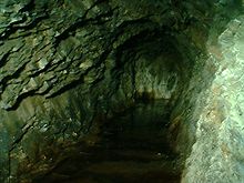
The adjoining rock consists of not particularly waterproof manganese - slate . So that the water pressure from below does not raise the wall, the base is relieved by more than 40 bells with risers. The water pressure that builds up is measured at intervals. Using a dead tunnel , the long-term behavior of the rock is examined. In addition, the wall is criss-crossed by two inspection corridors for inspection purposes.
Hydroelectric power plant
Between 2007 and 2009, a Kaplan turbine (double-regulated spiral turbine) was installed in the dam of the Wendefurth dam , which has since been generating electricity in a small hydropower plant with an installed capacity of 837 kW . In addition, there is power generation at the attached Wendefurth pumped storage plant .
Reservoir
location
The Wendefurth reservoir is located near the village of Wendefurth, mostly in the area of the city of Thale ; only the part on the air side of the dam of the Rappbode dam and its western foothills in the direction of the influence of the Bode belong to the town of Oberharz am Brocken . It is located between the nearby federal road 81 (Wendefurth – Hasselfelde) in the southeast and the somewhat distant federal road 27 (Blankenburg – Elbingerode) in the northwest, with the state road 96 (around Wendefurth– Rübeland ) in the southwest and the L 94 ( Almsfeld - Hüttenrode ) run in the northeast between the two federal highways. The dammed flowing water is the Bode, a tributary of the Saale in the catchment area of the Elbe ; In addition, the Rappbode , which previously flows through the Rappbodestausee, and a few small streams flow into the reservoir. Downriver along the now water- dammed Bode valley lie the Schieferberg ( 456.2 m ), the somewhat distant Kuhberg ( 469.2 m ) and the Wendefurther Berg ( 446.1 m ) on the left side of the forest-lined reservoir and the Nickelsberg ( 488 , 2 m ), the Kohlenberg (approx. 495 m ) and the Kirchhofsberg ( 452.3 m ).
Data
The reservoir is about 78 ha (0.78 km²) in size. It extends roughly in a west-east direction for around 3.5 km and is around 200 m wide near the dam. It has around 7.2 million m³ of storage space and 9.22 million m³ of total storage space . Its target is 351.9 m above sea level. NN . The catchment area is 309.20 km². The flood protection area is 5.67 million m³ in the cold season. The mean inflow is 5.02 m³ / s and the design flood is 191.7 m³ / s.
tourism
The operator, the Saxony-Anhalt dam company, also makes the Wendefurth dam available for visitors to visit. In a subsequent machine park, visitors can view disused assemblies.
A vantage point (approx. 370 m ; ⊙ ) located in the forest near the dam wall above the reservoir is included in the system of stamping points of the Harz hiking pin as No. 62 with the name Wendefurth reservoir (mountain side) .
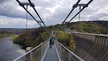
The Megazipline double rope slide and the Titan RT pedestrian suspension bridge are also available; both span the part of the reservoir of the Wendefurth dam that joins the air side of the dam of the Rappbode dam. The slide is around 1000 m long and the free-hanging section of the 483 m long bridge is 458.5 m.
See also
Individual evidence
- ↑ a b c d e f g h i j Deutsches Talsperrenkomitee (Ed.): Talsperren in Deutschland , Springer Vieweg Verlag, Wiesbaden, 2013, ISBN 9783834814470 , p. 391
- ↑ a b c d e Wendefurth dam (and other dams) in the northern dam area , at the Saxony-Anhalt dam operation, on talsperren-lsa.de
- ↑ a b c d e f g h i j k l m The history of the origin of the system of the "Bode dams with information and photos, on harzkaleidoskop.de (see especially the section The Wendefurth dam )
- ↑ a b c according to information on hydropower plants (WKA) that was previously visible, e.g. B. WKA at the Wendefurth dam , on hydroprojekt.de (accessed on September 27, 2012)
- ↑ a b Map services of the Federal Agency for Nature Conservation ( information )
- ↑ Saxony-Anhalt viewer of the State Office for Surveying and Geoinformation ( notes )
- ↑ Harzer Wanderadel: stamp point 62 / Wendefurth dam (dam view) [Wendefurth dam (mountain side)] , on harzer-wandernadel.de
literature
- Dams in Saxony-Anhalt. Dam management of the state of Saxony-Anhalt, 1994
Web links
- Wendefurth dam (and other dams) in the north area , at the dam operation of Saxony-Anhalt, on talsperren-lsa.de


