
Pöhl dam
| Pöhl dam | |||||||||
|---|---|---|---|---|---|---|---|---|---|
 |
|||||||||
|
|||||||||
|
|||||||||
| Coordinates | 50 ° 32 '28 " N , 12 ° 11' 41" E | ||||||||
| Data on the structure | |||||||||
| Construction time: | 1958-1964 | ||||||||
| Height above valley floor: | 47.85 m | ||||||||
| Height above foundation level : | 61.55 m | ||||||||
| Height of the structure crown: | 379.25 m | ||||||||
| Building volume: | 160 000 m³ | ||||||||
| Crown length: | 312 m | ||||||||
| Crown width: | 10.5 m | ||||||||
| Radius of curvature : | 600 m | ||||||||
| Power plant output: | 0.75 MW | ||||||||
| Data on the reservoir | |||||||||
| Altitude (at congestion destination ) | 375 m | ||||||||
| Water surface | 3.87 km² | ||||||||
| Storage space | 62 million m³ | ||||||||
| Total storage space : | 69 million m³ | ||||||||
| Catchment area | 160 km² | ||||||||
| Design flood : | 136 m³ / s | ||||||||
 |
|||||||||

The Pohl dam is on the size of the storage space and the second largest on the amount of Absperrbauwerkes over foundation and on the water surface, the third largest dam in Saxony . The dam is used for flood protection , industrial water supply , low water increase , energy generation and recreational activities.
Dam wall and reservoir


The dam of the Pöhl dam is a curved concrete gravity dam . The dam was built between 1958 and 1964 near Jocketa (today part of the municipality of Pöhl ) in Vogtland (commissioning in 1964). The dam takes its name from the village of Pöhl, which is now under water. In fact, the underwater location serves as a diving attraction. The dammed body of water, the Trieb , is a tributary of the White Elster .
The dam has two pre- dams at the southeast end of the reservoir, which are prestressed concrete gravity dams : the Thossfell pre- dam and the Neuensalz pre-dam .
The reservoir itself is part of the 3920-hectare conservation area, "Pohl dam", which in 1994 by the District Office Plauen was placed under protection.
Leisure, tourism, sport
Swimming, shipping, sailing, diving and other recreational sports in the reservoir are possible (however, pleasure boats with internal combustion engines are not permitted), there is a campsite and extensive leisure activities, e.g. B. a climbing park. Passenger boat tours are offered on the dam in the summer months. There are regular sailing regattas, and many sailing clubs and a diving club are organized around the dam. In the summer season, the main bathing beach (FKK Helmsgrün) is guarded by the water watch during the day, regattas and diving competitions are also supervised. There is a triathlon every year. Hiking around the reservoir is also possible on a stretch of almost twenty kilometers.
Observation tower
At 433.2 m above sea level NHN high Eisenberg above the dam has been a 14 m high observation tower since 1897 . The former Charlotte tower called Tower in 1953 on the 150th anniversary of the Vogtland regional poet Julius Mosen in Mosen Tower renamed. From the viewing platform you have a beautiful panoramic view of the dam.
The legend of the church tower
A legend says that when the tide was low you could see the old church tower of the submerged village of Pöhl, that nets got stuck on it or that you could sometimes hear the church bells. However, this cannot be the case, as all buildings including the church and castle were razed and removed before the reservoir was dammed. Remnants were later blown up for security reasons. When the tide is low, the foundation walls of the village can actually still be seen about 500 m from the dam, and divers visit the ruins.
gallery

The Pöhl, demolished because of the dam, in a view from 1844

Pre-lock at Neuensalz

Dam wall

Throttle valve and plaque on the dam wall
Outflow of the dam
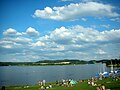
Sunbathing lawn on Gunzenberg

Holiday village Talsperre Pöhl (1977)

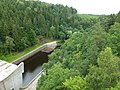
Motorway bridge over the Pöhl dam

Jetty at the Pöhl dam

Pöhl dam, view from the dam

Mosenturm near the dam

GDR postage stamp from 1968


_1968,_MiNr_1401.jpg)
See also
Individual evidence
- ↑ Landscape protection areas in Saxony ( Memento of the original from November 20, 2015 in the Internet Archive ) Info: The archive link was inserted automatically and has not yet been checked. Please check the original and archive link according to the instructions and then remove this notice.
- ↑ Tour # 5860: Around the Pöhl Dam on gps-tour.info
- ↑ Map services of the Federal Agency for Nature Conservation ( information )
- ↑ The Mosenturm on the Eisenberg ( Memento of the original from December 29, 2015 in the Internet Archive ) Info: The archive link was automatically inserted and not yet checked. Please check the original and archive link according to the instructions and then remove this notice. on the website of the Zweckverband Talsperre Pöhl