
Tanzawa hill country


The Tanzawa Mountains ( Japanese 丹 沢 山地 , Tanzawa-sanchi ) is a Japanese mountain region in Kantō , the central area of which is occupied by the Tanzawa-Ōyama-Quasi-National Park. The hill country is located in the northwestern part of Kanagawa Prefecture and is bordered by Shizuoka Prefectures in the west and Yamanashi in the north.
Overview
Due to its good transport links ( Odakyū Odawara Line ), the mountainous region is an important local recreation area for the Tokyo-Yokohama metropolitan area . There is good access from Shibusawa ( 渋 沢 ) and Hadano ( 秦 野 ) train stations.
- From Shibusawa the standard ascent of Okura ( 大 倉 ) begins , which can be reached by bus from Shibusawa Station. From there it is possible to climb the 1,491 m high Tōnodake ( 塔 ノ 岳 ) on a well-developed path over the Hanadate as a day trip. Marked hiking trails and mountain huts also allow multi-day mountain tours in the Tanzawa Mountains.
- From Hadano the ascent goes over the Yabitsu pass ( 矢 櫃 峠 , Yabitsu tōge ), then the path splits: one leads to Ōyama , the other enables via Ni-no-tō ( 二 ノ 等 ), San-no-tō ( 三 ノ 等 ) and the Toriiyama ( 鳥 尾 山 ) connect to the western mountains.
The mountain flanks offer opportunities for “ climbing up the stream ” ( 沢 登 り sawa-nobori ) , which is popular in Japan . In this sport you wade through a watercourse up to the ridge, whereby gorges with narrow waterfalls up to 15 m have to be overcome.
Despite its relatively low altitude, the Tanzawa mountain range is often covered in snow by half a meter or more in winter. At the end of winter, the paths can become impassable due to thawing and freezing processes, and in spring they can be covered with mud on the still frozen ground.
The mountain country
- Hiru-ga-dake ( 蛭 ヶ 岳 , 1672.7 m)
- Fudō-no-mine ( 不 動 ノ 峰 , 1614 m)
- Onigaiwa no atama / kashira ( 鬼 ヶ 岩 ノ 頭 , 1608 m)
- Hinokiboramaru ( 檜 洞 丸 , 1600 m)
- Tanasawa no atama / kashira ( 棚 沢 ノ 頭 , 1590 m)
- Ōmuro-yama ( 大 室 山 , 1587.6 m)
- Tanzawa-yama ( 丹 沢 山 , 1567.1 m)
- Kumasasa-no-mine ( 熊 笹 の 峰 , 1523 m)
- Ryūga-bamba ( 竜 ヶ 馬 場 , 1504 m)
- Dōkaku no atama / kashira ( 同 角 ノ 頭 , 1491 m)
- Teshiro no atama ( テ シ ロ ノ 頭 , 1491 m)
- Tōnodake ( 塔 ノ 岳 , 1490.9 m)
Other well-known peaks are:
- Nabewari-yama ( 鍋 割 山 , 1272.5 m)
- Ōyama ( 大 山 , 1251.7 m)
Tōnodake
The Tōnodake is not one of the highest peaks in the national park, but located on the southern edge it offers the best view of the foothills to the sea. Fuji , 30 km away, can also be clearly seen from there on a clear day. The mountain hut Sombutsu sansō ( 尊 仏 山 荘 ) stands on the mountain and offers overnight accommodation.
Nabewari-yama
On the Nabewari-yama stands the Nabeyama sansō mountain hut , which Kusano Nobetaka (* 1948), a mountaineer with Himalayan experience, has built and operates almost alone since 1985. While the Japanese military occasionally makes helicopters available for lifting loads as part of exercise missions today, Kusano carried the building material up on his back, despite his handicap: he lost seven toes due to frostbite during a Himalayan ascent.
Ōyama
The Ōyama, located to the east and separated from the Tanzawa mountain range by the Yabitsu Pass, has been venerated as a sacred mountain since ancient times because of its regular shape, despite its low height . It has been the destination of pilgrimages since the middle Edo period .
gallery

Hut on the Tonodake
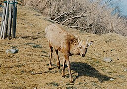
Chamois on the Tonodake

Hut on the Nabewari
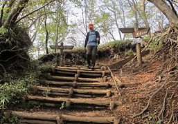
Path in the mountains

Waterfall on Ōyama

Signpost in winter


Remarks
- ↑ The special protection zone is shown in red.
- ↑ Hiru is the leech .
- ^ Woodcut by Katsushika Hokusai from his series of waterfalls.
literature
- Haga Shōtaro: Tanzawa. Arupusu gaido 37. Yama to Keikoku-sha, 1981.
- Tanzawa: Yama to Kogen chizu 21 Shobun-sha 1995, ISBN 4-398-75021-5 . (Card 1.40000 with booklet)
- Paul Hunt: Hiking in Japan: An Adventurer's Guide to the Mountain Trails . Kodansha America, ISBN 978-0-87011-893-7
Web links
Coordinates: 35 ° 28 ′ 59 ″ N , 139 ° 9 ′ 15 ″ E