Tarime (district)
| Tarime district | |
|---|---|
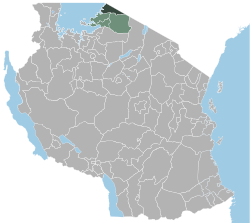
 Location of the Tarime district in Tanzania |
|
| Basic data | |
| Country | Tanzania |
| region | Mara |
| surface | 1637 km² |
| Residents | 339,693 (2012) |
| density | 208 inhabitants per km² |
| ISO 3166-2 | TZ-13 |
Coordinates: 1 ° 21 ′ S , 34 ° 21 ′ W
Tarime is a district of the Mara region in Tanzania , the administrative center is in the city of Tarime. The district borders in the northeast on Kenya , in the southeast on the Serengeti district , in the southwest on the Butiama district , in the west on the Rorya district and in the northwest on Lake Victoria .
geography
The district is 1637 square kilometers and has around 340,000 inhabitants (as of 2012). The area consists of two geographical zones:
- The highlands in the north are 1500 to 1800 meters above sea level. It rains 1200 to 1600 millimeters annually.
- The land in the southwest and southeast of the district has an altitude of 1,300 to 1,500 meters and annual rainfall of 900 to 1,250 millimeters.
The climate is tropical, Aw according to the effective climate classification . The precipitation falls over the whole year, the driest month is July with around 40 millimeters of rain. There are two precipitation peaks, one in November and the highest in April with over 200 millimeters of rain.
history
The district was established on January 1, 1984.
Administrative division
The district is divided into four divisions and 30 parishes (wards) (as of 2015):
Ingwe
|
Inchage
|
Inano
|
Inchugu
|
population
About 15 percent of the district's population live in the urban areas of Sirari, Nyamongo and Nyamwaga, 85 percent live in rural areas. The largest ethnic group are the Kuria , who belong to the Luo .
Facilities and services
- Education: There are 134 primary schools in the district, 116 of which are public and 18 are private. Of the 31 secondary schools, two are private (as of 2019).
- Health: Five health centers and sixteen pharmacies provide medical care for the population (as of 2019).
- Water: Of the 64,000 households, 23 percent had access to clean and safe water, 57 percent got their water from unprotected sources, 13 percent got water from lakes or rivers and 6 percent used rainwater (as of 2012).
Economy and InfrastructureThe main economic activities are agriculture, mining and fishing. In 2014, agriculture contributed 30 percent to the gross domestic product (GDP), mining 39 percent and fishing six percent. Of the 130,000 employees, 72 percent were employed in agriculture and forestry, one percent in fishing and three percent in mining (as of 2012).
|
 |
 |
- Roads: The most important road is the T4 national road, which crosses the district from Mwanza in the southwest and leads to Kenya.
Nature reserves, sights
- Lake Victoria: In the west of the district is Lake Victoria, which is the largest lake in Africa at 68,000 square kilometers.
- Serengeti National Park : In the east, the district has a share of the 14,763 square kilometers large Serengeti National Park.
Personalities
Dickson Marwa (* 1982), long-distance runner
Web links
Individual evidence
- ↑ Tanzania Regional Profiles, 20 Mara Regional Profiles. (PDF) The United Republic of Tanzania, 2016, p. 16 , accessed on February 3, 2020 .
- ↑ a b History | TARIME DISTRICT COUNCIL. Retrieved February 3, 2020 .
- ↑ a b Tarime District Council Strategic Plan 2014 / 2015-2019 / 2020. (PDF) May 2015, pp. 4–5 , accessed on February 4, 2020 .
- ↑ Tarime climate: Average Temperature, weather by month, Tarime weather averages - Climate-Data.org. Retrieved February 4, 2020 .
- ↑ Tarime District Council Strategic Plan 2014 / 2015-2019 / 2020. (PDF) May 2015, pp. 2–3 , accessed on February 4, 2020 .
- ↑ a b Statistics | TARIME DISTRICT COUNCIL. Retrieved February 3, 2020 .
- ↑ Tanzania Regional Profiles, 20 Mara Regional Profiles. (PDF) The United Republic of Tanzania, 2016, p. 115 , accessed on February 3, 2020 .
- ↑ a b Mining | TARIME DISTRICT COUNCIL. (PDF) pp. 5–6 , accessed on February 4, 2020 .
- ↑ Tanzania Regional Profiles, 20 Mara Regional Profiles. (PDF) The United Republic of Tanzania, 2016, p. 101 , accessed on February 3, 2020 .
- ↑ Tanzania Regional Profiles, 20 Mara Regional Profiles. (PDF) The United Republic of Tanzania, 2016, pp. 130, 133 , accessed on February 3, 2020 .
- ↑ Mining | TARIME DISTRICT COUNCIL. (PDF) pp. 2, 4 , accessed on February 4, 2020 .
- ^ Tanzania Trunk Road Network. Retrieved February 4, 2020 .
- ↑ Lake Victoria. Retrieved on February 4, 2020 (German).
- ↑ Tanzania in Figures 2018. (PDF) National Bureau of Statistics, 2019, p. 8 , accessed on February 4, 2020 .
- ↑ PeoplePill: Dickson Marwa: Tanzanian long-distance runner - Biography and Life. Retrieved April 28, 2020 (American English).


