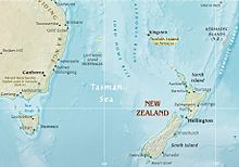
Tasman Sea
As Tasman or Tasman Sea water area between is Australia and New Zealand , respectively. It is a southwestern part of the South Pacific . The name honors the Dutch explorer Abel Tasman , who went on a voyage of discovery in 1642/1643 and discovered New Zealand and Tasmania in the process. Around 1770, the British explorer James Cook explored the area during his first voyage of discovery.
The International Hydrographic Organization counts the areas east of the Australian states of New South Wales , Victoria and Tasmania as part of the Tasman Sea . Queensland , located further to the north , is connected to the Coral Sea . The border between the states also serves to demarcate these two seas .
The Tasman Sea is 2800 km long and up to 2000 km wide, the surface area is 2,331,000 km². It reaches its greatest depth with 5200 m in the Tasmanian Basin.
Islands
The Tasman Sea contains a number of archipelagos that are remote from the coastal islands of New Zealand and Australia:
- Middleton Reef and Elizabeth Reef (each with a small island on the fringing reef) are also located north of the Tasmanian Sea.
- Lord Howe Archipelago , with Lord Howe Island , Ball's Pyramid and other associated islands
- Norfolk Island far to the north, on the border with the Coral Sea
These islands all belong to Australia .
Crossing
Colin Quincey was the first person to cross the Tasman Sea from New Zealand to Tasmania in a rowboat in 1977 . His son Shaun Quincey was the first to drive from Tasmania to New Zealand in 2010. The Australian Andrew McAuley has been missing since his attempt to travel from Tasmania to New Zealand in a sea kayak in 2007.
Coordinates: 37 ° S , 161 ° E
Individual evidence
- ↑ Adventurer rowed alone from Australia to New Zealand. In: Spiegel Online. March 15, 2010, accessed November 29, 2014 .

