Teedriinjik River
|
Teedriinjik River, Chandalar River, North Fork Chandalar River |
||
|
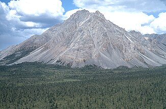
Forested Valley of the Teedriinjik River (Chandalar River) |
||
| Data | ||
| Water code | US : 1400141 | |
| location | Alaska (USA) | |
| River system | Yukon River | |
| Drain over | Yukon River → Bering Sea | |
| Headwaters |
Brook chain 68 ° 10 '59 " N , 149 ° 16'7" W. |
|
| Source height | approx. 1700 m | |
| muzzle |
Yukon River Coordinates: 66 ° 36 ′ 33 " N , 146 ° 0 ′ 9" W 66 ° 36 ′ 33 " N , 146 ° 0 ′ 9" W |
|
| Mouth height | 118 m | |
| Height difference | approx. 1582 m | |
| Bottom slope | approx. 1.5 ‰ | |
| length | approx. 1050 km | |
| Discharge at the Venetie A Eo gauge : 25,000 km² Location: 110 km above the estuary |
MQ 1964/1973 Mq 1964/1973 |
142 m³ / s 5.7 l / (s km²) |
| Left tributaries |
Ch'idriinjik River (Middle Fork Chandalar River), East Fork Chandalar River |
|
| Right tributaries | West Fork Chandalar River | |
| Flowing lakes | Chandalar Lake | |
| Communities | Venetie | |
| West Fork Chandalar River | ||
| Water code | US : 1411859 | |
| location | Alaska (USA) | |
| River system | Yukon River | |
| Drain over | Teedriinjik River → Yukon River → Bering Sea | |
| Headwaters |
Brook's chain 67 ° 12 '47 " N , 149 ° 18' 26" W. |
|
| muzzle | Teedriinjik River (North Fork Chandalar River) 67 ° 11 ′ 18 " N , 148 ° 30 ′ 54" W |
|
| Mouth height |
397 m
|
|
| East Fork Chandalar River | ||
|
East Fork of the Chandalar River in the Brooks Range |
||
| Data | ||
| Water code | US : 1397853 | |
| location | Alaska (USA) | |
| River system | Yukon River | |
| Drain over | Teedriinjik River → Yukon River → Bering Sea | |
| source |
Brook chain 68 ° 59 ′ 52 ″ N , 144 ° 6 ′ 26 ″ W. |
|
| muzzle | Teedriinjik River (Chandalar River) 67 ° 6 ′ 6 ″ N , 147 ° 14 ′ 19 ″ W |
|
| Mouth height |
254 m
|
|
| length | 280 km | |
| Right tributaries | Wind river | |
| Communities | Arctic Village | |
The Teedriinjik River (official river name since 2015; includes the rivers of Chandalar River and North Fork Chandalar River ) is an approx. 1050 km long right tributary of the Yukon River in the northern interior of Alaska .
The Teedriinjik River has its source near the Atigun Pass in the Brooks range . On the upper reaches of the North Fork is the Chandalar Shelf, a shallow valley east of the Dalton Highway that caribou use for wintering. It flows mainly in a southerly direction through the mountains. It flows through the Chandalar Lake . In the lower reaches it turns east and south-east. It takes in the tributaries of the West Fork Chandalar River , Ch'idriinjik River (formerly Middle Fork Chandalar River ) and East Fork Chandalar River . It passes the settlement of Venetie and flows into the Yukon River about 35 km west of Fort Yukon .
West Fork Chandalar River
The West Fork Chandalar River is a shorter right tributary.
East Fork Chandalar River
The headwaters of the East Fork Chandalar River is near the Romanzof Mountains in the eastern Brooks range. Arctic Village is located on this tributary. The Wind River , designated as the National Wild and Scenic River , flows into the East Fork . About 50 km below the confluence of the Ch'idriinjik River, the East Fork flows into the main river from the north.
Naming
The former name of the river, Chandalar River , has its origins in the name given by the French employees of the Hudson's Bay Company in Fort Yukon for the Gwich'in who lived along the river, meaning "nomadic people". The transfer of the French pronunciation into the English spelling led to the current name "Chandalar" (initially also partly written as "Chand-da-larg"). The native name for the river was "Achenchik".
The current Indian river name comes from the Gwich'in language and means "shining river" or "shimmering river".
Web links
Individual evidence
- ↑ a b c d Teedriinjik River in the Geographic Names Information System of the United States Geological Survey
- ↑ USGS 15389500 CHANDALAR R NR VENETIE AK
- ↑ West Fork Chandalar River in the Geographic Names Information System of the United States Geological Survey
- ^ A b East Fork Chandalar River in the Geographic Names Information System of the United States Geological Survey

