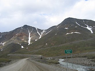
Atigun Pass
| Atigun Pass | |||
|---|---|---|---|
|
|
|||
| Compass direction | south | North | |
| Pass height | 1415 m | ||
| US state | Alaska ( USA ) | ||
| Watershed | Dietrich River → Middle Fork Koyukuk River → Koyukuk River → Yukon River | Atigun River → Sagavanirkenok River | |
| Valley locations | Coldfoot | Deadhorse | |
| expansion |
|
||
| Mountains | Brook chain | ||
| map | |||
|
|
|||
| Coordinates | 68 ° 7 ′ 48 ″ N , 149 ° 29 ′ 6 ″ W | ||
The Atigun Pass is a 1415 m high mountain pass in the Brooks range between the Endicott Mountains in the west and the Philip Smith Mountains in the east.
It is located in the North Slope Borough of the US state Alaska , a few kilometers north of the border with the Yukon-Koyukuk Census Area .
The Atigun is the only pass in the Brooks range that is crossed by a road, the Dalton Highway ( Alaska Route 11 ) from Fairbanks to Prudhoe Bay on the Beaufort Sea . It is the highest pass in Alaska and is kept navigable all year round.
The Atigun Pass is part of the North American continental divide that separates the catchment areas of the Pacific and Arctic Oceans .
The Arctic National Wildlife Refuge begins to the east of the pass and the Gates of the Arctic National Park to the west .


