Pool of the Sons of Israel
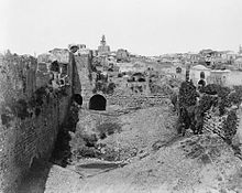
The Pond of the Sons of Israel was a pool of water in the UNESCO World Heritage Site of the Old City of Jerusalem . It was a significant part of the historic water supply system in the city, particularly the temple precinct . It had a rectangular shape and was 38 m wide (in north-south direction), 110 m long and 27 m deep.
Surname
The name Pool of the Sons of Israel בריכת בני ישראל brikat bani jisrael was first used in 985 by al-Muqaddasī . This derived the name from the tribal gate , which was formerly called the Gate of the Sons of Israel and is located at the southeast corner of the pond. Only Ali ibn abi bakr al-Harawi provided a legendary interpretation in the 12th century, according to which Nebuchadnezzar filled the pond with the heads of the slain children of Israel when he conquered Jerusalem .
geography
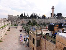
The Pool of the Sons of Israel is just outside the northern wall of the Temple Mount at its northeast corner. The northern wall of the Temple Mount forms its south side. On its east side is the city wall of Jerusalem . The wide embankment on its east side leads to the tribal gate in the corner between the city wall and the wall of the Temple Mount. The Löwentor is located on its northeast corner . Löwentorstraße runs on its north side . On its west side is the König-Faisal-Strasse and on its south-west corner the Atonement Gate . Since the pond was filled in by the British in the 1930s, there has been a large parking lot to the west and the park-like El Ghazali Square to the east.
history
The Pool of the Sons of Israel was created between 20 and 10 BC. At that time, Herod the Great expanded the temple square to its present size. This closed off the Bezeta valley to the south, and the north wall of the temple square formed the dam. The newly created large basin, the southern wall of which was used as the northern wall of the Temple Square, stored the water flowing down through the valley. To the west, two arched galleries compensated for the slope of the rock. To the east, towards the Kidron valley , a 14 m wide dam supported the basin. He regulated the water drainage through an overflow at a height of 6.7 m towards the Kidron valley. The underground stone layers are clearly Herodian and testify to this dating. This water reservoir was important for the large water consumption of the Jewish temple business.
After the conquest of Jerusalem by the Roman general Titus in 70 and the associated destruction of the temple , the pond of the Sons of Israel was used to supply the city's residents with water.
It was restored in Byzantine times , as evidenced by a cross in the water chamber of the east dam.
During the time of the Crusades , the name “sheep pond” shifted from the (older) water basins 100 m further north to the pond of the Sons of Israel. This is shown by the map of Cambrai from the year 1150, in which the pond of the Sons of Israel was first entered as “piscina probatica” (= sheep pond).
The crusaders had built the small church "Le Moustier" (Moustier from French: Monastère, Latin: monasterium, German: monastery ) on the embankment between the two basins of the sheep pond and commemorated the healing of the paralyzed at the sheep pond Joh 5,1-15 EU . Nevertheless , the Knights Templar succeeded in shifting the shank tradition to the pond of the Sons of Israel. This pond has been given a stronger attraction for Christian pilgrims by the giving of indulgences .
As early as 1238, Burchardus de Monte Sion wrote : "If you have passed the valley or herd gate, you will immediately encounter the piscina probatica (= sheep pond) on the left next to the temple area." Various drawings, including by Charles William Wilson from 1880, show that this tradition lasted into the 19th century. Only after excavations in the area around St. Anne's Church in 1882 did the name Schafteich return to its original location.
Eventually the pond became a sanitary problem for local residents and was completely filled in by the British in the 1930s. A parking lot has been set up on its west side. Its east side forms a green, park-like square. It is through this square that Muslims get to the Gate of the Tribes and the Haram . At funerals, the corpses are carried across this square in a solemn procession to the cemetery behind the lion gate.
Web links
Individual evidence
- ↑ a b c d e Max Küchler : Jerusalem: A manual and study travel guide to the Holy City. Vandenhoeck & Ruprecht, Göttingen 2007, ISBN 978-3-525-50170-2 , pp. 311-313, 341-345.
- ↑ Pool of the Sons of Israel at OSM. Retrieved April 18, 2020.
- ↑ Jerusalem Teich Bethesda at israel-geo-guide.de. Retrieved April 18, 2020.
Coordinates: 31 ° 46 ′ 49.3 " N , 35 ° 14 ′ 11.9" E


