Telerig Nunatak
| Telerig Nunatak | ||
|---|---|---|
|
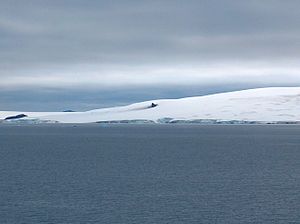
View from Half Moon Island to Telerig Nunatak (center) |
||
| height | 170 m | |
| location | Greenwich Island , South Shetland Islands | |
| Mountains | Dryanovo Heights | |
| Coordinates | 62 ° 29 '34 " S , 59 ° 55' 36" W | |
|
|
||
The Telerig Nunatak ( Bulgarian нунатак Телериг nunatak Telerig ) is a 170 m high nunatak on Greenwich Island in the archipelago of the South Shetland Islands . On the southwestern foothills of Dryanovo Heights, it rises 1.6 km southeast of Kersebleptes-Nunatak , 1.68 km south-southeast of Panagyurishte-Nunatak and 1.9 km west of Lloyd Hill .
Bulgarian scientists mapped it while surveying the Tangra Mountains on neighboring Livingston Island between 2004 and 2005. The Bulgarian Commission for Antarctic Geographical Names named it in 2005 after Telerig , a proto-Bulgarian Khan of the 7th century .
Web links
- Telerig Nunatak in the Composite Gazetteer of Antarctica (English)

