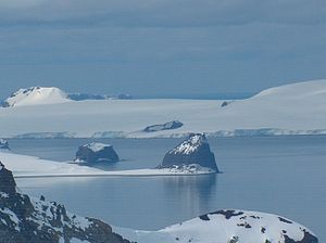
Kersebleptes Nunatak
| Kersebleptes Nunatak | ||
|---|---|---|
|
View from Losen-Nunatak over Inott Point (left) and Edinburgh Hill (right) to Kersebleptes-Nunatak on the coast of Greenwich Island |
||
| height | 90 m | |
| location | Greenwich Island , South Shetland Islands | |
| Coordinates | 62 ° 29 ′ 15 ″ S , 59 ° 57 ′ 22 ″ W | |
|
|
||
The Kersebleptes Nunatak ( Bulgarian нунатак Керсеблепт nunatak Kerseblept ) is a 90 m high nunatak on Greenwich Island in the archipelago of the South Shetland Islands . On the shores of McFarlane Strait, it rises 4 km south of Chrabr Nunatak and 3.5 km west of Lloyd Hill from the ice masses of Jakoruda Glacier .
Bulgarian scientists mapped it in the course of surveying the Tangra Mountains on the neighboring Livingston Island between 2004 and 2005. The Bulgarian Commission for Antarctic Geographical Names named it in 2005 after the Thracian king Kersebleptes ( 4th century BC ).
Web links
- Kerseblept Nunatak in the Composite Gazetteer of Antarctica (English)

