Temeke (District)
| Temeke district | |
|---|---|
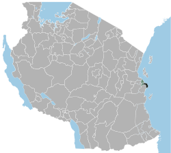
 Location of the Temeke district in Tanzania |
|
| Basic data | |
| Country | Tanzania |
| region | Dar es Salaam |
| surface | 656 km² |
| Residents | 1,368,881 (2012) |
| density | 2087 inhabitants per km² |
| ISO 3166-2 | TZ-02 |
Coordinates: 7 ° 0 ′ S , 39 ° 25 ′ E
Temeke is a district (Municipal Council) in the Tanzanian region of Dar es Salaam . It borders the Indian Ocean to the north and east, the Pwani region to the southwest and the Ilala district to the northwest .
geography
Temeke is the southernmost of the three districts of Dar es Salaam. It is 656 square kilometers and has 1,368,881 inhabitants (as of 2012).
The district is divided into
- the lowlands on the Yombo River, in the Keko Valley and on the Kigamboni Peninsula,
- the central plateau, where the majority of the population lives,
- the highlands, which include small wooded ridges.
The climate is tropical with two rainy seasons. The monsoon rains fall from December to February, and there are long showers from March to June. A total of 800 to 1200 millimeters of precipitation fall annually. The temperature is 25 degrees from June to August and 35 degrees Celsius from January to March.
history
The district was established in 1999.
Administrative division
Temeke is divided into the three divisions Kigamboni, Mbagala and Chan'gombe and into 30 districts (wards):
- Kigamboni
- Vijibweni
- Kibada
- Kisarawe II
- Somangila
- Kimbiji
- Mbagala
- Chamazi
- Yombo Vituka
- Charambe
- Toangoma
- Miburani
- Temeke
- Mtoni
- Cookies
- Kurasini
- Azimio
- Tandika
- Sandali
- Chang'ombe
- Mbagala Kuu
- Makangarawe
- Pembamnazi
- Mjimwema
- Tungi
- Kijichi
- Mianzini
- Kiburugwa
- Buza
- Kilakala
populationThe population grew from 401,786 in 1988, to 768,451 in 2002 and to 1,368,881 in 2012. This means that the annual growth rate rose to over five percent and the number of inhabitants doubles every twelve years. Of those over five, two thirds spoke Swahili and a fifth spoke Swahili and English. The proportion of illiterate people was eight percent (as of 2012). Facilities and services |
 |
- Education: 83 primary schools and 61 secondary schools are available for the education of young people (as of 2019). The African University of Tanzania is located on the eastern edge of urban Temeke.
- Water: The daily water requirement of 115 million liters is offset by a well supply of 78 million liters. This means that almost a third of the population has no access to safe and clean water.
Economy and InfrastructureIn the primary economic sector, twelve percent of the workforce worked, six percent in agriculture, three percent in fishing and four percent in mining. Services and trade are very pronounced.
|
 |
Web links
Individual evidence
- ^ A b Tanzania Regional Profiles, 07 Dar es Salaam Regional Profile. (PDF) The United Republic of Tanzania, 2016, p. 15 , accessed on January 31, 2020 .
- ↑ a b Economic Activities | Economic and Social Profile of 2010/2011. (PDF) p. 2 , accessed on January 31, 2020 .
- ↑ Economic Activities | Economic and Social Profile of 2010/2011. (PDF) pp. 3–4 , accessed on January 31, 2020 .
- ↑ Economic Activities | Economic and Social Profile of 2010/2011. (PDF) p. 8 , accessed on January 31, 2020 .
- ↑ 2012 Population and Housing Census. (PDF) National Bureau of Statistics and Ministry of Finance, March 2013, p. 77 , accessed January 30, 2020 .
- ^ Tanzania Regional Profiles, 02 Dar es Salaam Regional Profiles. (PDF) The United Republic of Tanzania, 2016, p. 55 , accessed on January 31, 2020 .
- ↑ Statistics | Temeke Municipal Council. Accessed January 31, 2020 .
- ↑ Google Maps. Retrieved February 1, 2020 (de-US).
- ↑ Huduma ya Maji | Temeke Municipal Council. Retrieved February 1, 2020 (Swahili).
- ↑ DEPARTMENT OF AGRICULTURE, IRRIGATION AND COOPERATIVES. Accessed February 1, 2020 .
- ^ Social Economic Profile 2010/2011. (PDF) Teneke Municipal Council, pp. 30–31 , accessed on February 1, 2020 .
- ↑ The Economic Survey 2017. (PDF) Ministry of Finance and Planning, July 2018, p. 175 , accessed on January 31, 2020 .
- ↑ a b Vivutio vya Kitalii | Temeke Municipal Council. Retrieved January 31, 2020 (Swahili).
- ↑ Tanzania National Stadium - Dar es Salaam - The Stadium Guide. Retrieved February 1, 2020 (American English).


