Tempelberg (Lower Austria)
| Temple mount | ||
|---|---|---|
|
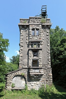
The Temple Mount Observatory at the highest point |
||
| height | 403 m above sea level A. | |
| location | near Greifenstein , Lower Austria | |
| Mountains | Vienna Woods | |
| Coordinates | 48 ° 20 '16 " N , 16 ° 14' 35" E | |
|
|
||
| particularities | Temple Mount Observatory | |
The Temple Mount is 403 m above sea level. A. high elevation in the Vienna Woods and one of the last foothills of the Alps . At the foot of the mountain lies Greifenstein Castle . The closest places Altenberg, Greifenstein and Hadersfeld are cadastral communities of the Lower Austrian municipality of Sankt Andrä-Wölker . The Greifenstein Danube power plant is located around two kilometers from the elevation .
Despite the low height of the mountain, one has a wide panorama from the Tempelbergwarte at the summit, which encompasses the Weinviertel in the north across the Danube and almost the entire Vienna Woods in the south and, when the visibility is good, extends to the Ötscher .
The Temple Mount can be reached via numerous marked hiking trails. They start, for example, in Wierter, Altenberg, Greifenstein, Höflein an der Donau or Kritzendorf .
literature
- Fritz Peterka: The local mountains of Vienna. Hikes and mountain tours between Leiser Mountains and Buckliger Welt, Leithagebirge and Ybbsthal Alps . Verlag Anton Schroll, Vienna 1985, ISBN 978-3-7031-0610-1 .

