
Greifenstein (municipality of St. Andrä-Wodge)
|
Greifenstein ( village ) locality cadastral community Greifenstein administrative district |
|||
|---|---|---|---|
|
|||
| Basic data | |||
| Pole. District , state | Tulln (TU), Lower Austria | ||
| Judicial district | Tulln | ||
| Pole. local community | St. Andrä-Wordern | ||
| Coordinates | 48 ° 20 ′ 40 " N , 16 ° 14 ′ 28" E | ||
| Residents of the village | 250 (January 1, 2020) | ||
| Building status | 89 (2011) | ||
| Area d. KG | 3.96 km² | ||
| Post Code | 3422 3422 | ||
| prefix | + 43/2242 | ||
| Mayor | Krieber Werner, local councilor OV | ||
| Statistical identification | |||
| Locality code | 06257 | ||
| Cadastral parish number | 20127 | ||
| Counting district / district | Greifenstein (32142 002) | ||
| Source: STAT : index of places ; BEV : GEONAM ; NÖGIS | |||

Greifenstein is a riverside village northwest of Klosterneuburg on the right bank of the Danube with 330 inhabitants (as of 2001). It belongs to the Lower Austrian market town of St. Andrä-Wölker and has grown together with the neighboring town of Altenberg.
The village is known on the one hand for the Greifenstein Castle and on the other for the Greifenstein Danube run-of-river power station .
geography
The village of Greifenstein is located south of the Danube and has an area of 3.97 km².
history
Greifenstein was mentioned in a document in 1135 and with its castle was the eastern cornerstone of the Passau possessions.
As part of the community reform, the community of Greifenstein was merged with the communities of St. Andrä vor dem Hagenthale, Wrogen, Hintersdorf and Kirchbach to form the market community of St. Andrä-Wierter in 1972 .
Attractions
- Filialkirche Maria Sorg: The Filial (since 2013) and pilgrimage church was built between 1953 and 1966 according to plans by Hans Petermair in a dominant high position above the Danube . The sacred building with a presented north tower has a "castle character" due to the clunky masonry.
- Greifenstein Castle : The castle is a highmedieval complex built around 1100on a towering rocky promontory at the northeasternmost point of the Vienna Woods - thus the northeasternmost castle in the Alps . In 1477 it wasconqueredby Matthias Corvinus (1443–1490), King of Hungary and Croatia, and in 1529by the Turks during the first Turkish siege of Vienna . It was expanded in the 17th century. As a result of the roof tax introducedby Emperor Joseph II (1741–1790)at the end of the 18th century, it fell into disrepair. In 1818 thecastle was restored by Prince Johann Joseph von Liechtenstein (1760–1836) after he had acquired it in 1807.
- Greifenstein power plant : The run-of- river power plant was built by Österreichische Donaukraftwerke AG as the eighth barrage on the Danube in Austria between 1981 and 1985 and is now owned by VERBUND Hydro Power GmbH . The approximately 450 m wide dam dammed the Danube at river kilometer 1,949.18 m over a length of about 31 km and a maximum height of 12.6 m. The system consists of two locks , a weir with 6 weir fields and a machine house with 9 machine sets, each with a turbine and a generator . The power plant delivers a bottleneck capacity of 293 megawatts .
leisure
The old arm of the Danube with its sunbathing lawns and bathing bays is a local recreation area in Vienna that is easy to reach with the S40 or via the Danube Cycle Path . There is the possibility of trips with the pedal boat . The berths on the north side of the water are also often used for nudist bathing.
Picture gallery
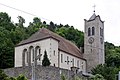
The Maria Sorg branch church with the mighty church tower

Greifenstein Castle (seen from the Temple Mount Observatory)
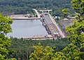
The Danube power plant Greifenstein (seen from the Tempelbergwarte)


Web links
- Greifenstein on the side of the market town of St. Andrä-Wierter
- Description of Greifenstein in representation of the Archduchy of Austria under the Ens
- The association "Cooking without borders"
Individual evidence
- ↑ a b c Federal Monuments Office (ed.): Dehio-Handbuch. The art monuments of Austria. Lower Austria, south of the Danube , part 1, page 587f., Berger Verlag, Horn / Vienna 2003, ISBN 3-85028-364-X
- ↑ Statistics Austria : Dissolution or associations of municipalities from 1945 ( page no longer available , search in web archives ) Info: The link was automatically marked as defective. Please check the link according to the instructions and then remove this notice. (LGBL. NÖ. No. 264/1971); Retrieved December 14, 2012
- ↑ Pfarrbatt Zeiselmauer. (No longer available online.) September 2013, archived from the original on July 25, 2015 ; Retrieved July 24, 2015 . Info: The archive link was inserted automatically and has not yet been checked. Please check the original and archive link according to the instructions and then remove this notice.
- ^ Verbund AG: Greifenstein run-of-river power plant, detailed data

Cadastral communities: Altenberg | Greifenstein | Hadersfeld | Hintersdorf | Kirchbach | St. Andrä | Words
Locations: Altenberg | Greifenstein | Hadersfeld | Hintersdorf | Kirchbach | St. Andrä in front of the Hagenthale | Words
Market place: Wierter Villages: Altenberg | Greifenstein | Hadersfeld | Hintersdorf | Oberkirchbach | St. Andrä in front of the Hagenthale | Steinriegl | Unterkirchbach settlements: Badesiedlung | Rotten cemetery settlement : Arzgrub | Haselbach Scattered houses: Hagental Other locations: Burg Greifenstein | Altenberg Castle | Hadersfeld Castle
Counting district: Wierter-Zentrum | Words environment | Greifenstein | Altenberg | Hadersfeld | St.Andrä vdHagenthale | Hintersdorf | Kirchbach