
The Oa

The Oa ( Scottish Gaelic : An Obha ), historically also called The Oe or Mull of Kinoe , is a peninsula on the Scottish island of Islay .
geography
Oa is located on the south coast of the island and Cape Rubha nan Leacan in the southeast of the peninsula marks the southernmost point of Islay. At its greatest extent in east-west direction it measures about seven kilometers, in north-south direction it is about 6.5. In the northeast it is connected to the main part of the island. To the south and east it is bounded by the Atlantic Ocean , while the bay of Loch Indaal forms the west coast. On the opposite coast from Loch Indaal is the Rhinns of Islay peninsula. While mostly flat, sandy coasts occur in the south of the island, cliffs up to 220 m high delimit the Mull of Oa.
Administratively, Oa is part of Islay of the Council Area Argyll and Bute . Historically, it was part of what is now the traditional county of Argyllshire .
Before the Highland Clearances , Oa had a population of about 800 people, other sources speak of up to 4,000 people. Today the peninsula is inhabited by 40 people. Numerous remains of residential houses can be found in the landscape and testify to the former settlement.
A monument on the southwest coast on the Cape called Mull of Oa commemorates the shooting down of the ship Tuscania and the sinking of the Otranto off the coast during the First World War . During the Second World War a warship of the Royal Navy was named Mull of Oa (see also: List of Historic Ships of the Royal Navy ).
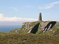
Monument on the Mull of Oa

Landscape on Oa

Oa across Loch Indaal seen from the Port Charlotte sports field .

Clyde Tomb from Cragabus


_near_Cragabus_-_geograph.org.uk_-_306978.jpg)
Individual evidence
- ^ List of Gaelic expressions
- ^ CI Jackson (Ed.): The Artic whaling Journals of William Scoresby the Younger, Vol. III: The Voyages of 1817, 1818 and 1820 , Ashgate Publishing, Farnham, 2009, p. 210. ISBN 978-0-904180-95 -4
- ↑ JM Wilson: Nelson's Hand-book to Scotland , T. Nelson and Sons, London, 1860, p. 282.
- ↑ Information on islayinfo.org
- ^ A b N. Wilson, A. Murphy: Scottland , Lonely Planet, 2006, p. 36. ISBN 978-3829715-68-3
- ^ D. Porter, D. Prince: Frommer's Great Britain , Wiley Publishing, Hoboken, 2nd Edition, 2003, p. 584. ISBN 978-0-764538-23-0
- ^ JJ Colledge, B. Warlow: Ships of the Royal Navy: The Complete Record of All Fighting Ships of the Royal Navy , Casemate, Havertown, 2009. ISBN 978-1-935149-07-1
Coordinates: 55 ° 36'53 " N , 6 ° 16'34" W.