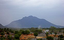
Theerthamalai
| Theerthamalai | ||
|---|---|---|
|
|
||
| State : |
|
|
| State : | Tamil Nadu | |
| District : | Dharmapuri | |
| Sub-district : | Harur | |
| Location : | 12 ° 6 ′ N , 78 ° 36 ′ E | |
| Height : | 320 m | |
| Area : | 2 km² | |
| Residents : | 2,055 (2011) | |
| Population density : | 1028 inhabitants / km² | |
| Theerthamalai - mountain | ||
Theerthamalai ( Tamil : தீர்த்தமலை = "Mountain of Sacred Water") is a village with around 2,000 inhabitants in the southern Indian state of Tamil Nadu . Halfway up a nearby 840 m high mountain is an important Shiva shrine.
location
Theerthamalai is located approx. 15 km (driving distance) northeast of Harur or approx. 70 km east of the district capital Dharmapuri at an altitude of approx. 320 m above sea level. d. M. The climate is usually warm to hot; Rain falls mainly during the monsoon months May to November.
population
The vast majority of the mostly Tamil- speaking inhabitants of the place are Hindus ; other religions hardly play a role in rural India. The male and female proportions of the population are almost equally high.
economy
Agriculture and, to a lesser extent, cattle breeding (cows, chickens) form the livelihood of the population. Small traders, craftsmen and service providers of all kinds have also settled in the village.
history
How far back the history of the place goes is unclear. The Theerthagirishwarar Temple is most likely from the 7th century; However, inscriptions from the Chola epoch (9th to 11th centuries) and the Vijayanagar period (14th / 15th centuries) make it likely to be expanded. Devout Hindus make a pilgrimage to the temple to collect holy water and fill it in bottles.
Attractions
The Theerthagirishwarar temple complex, consecrated to the Hindu god Shiva , is in an imposing location on a plateau of the rugged mountain landscape below the summit. The main temple consists of a large, but architecturally rather insignificant vestibule ( mandapa ) and the cella ( garbhagriha ) with a stepped tower structure ( vimana ) in the Dravida style . The tower structure shows pseudo-architecture and figures; However, it does not end in the “umbrella dome” typical of medieval architecture in South India, but in a kind of hood .
The main temple is surrounded by other small temples and an open hall.
Web links
- Theertamalai, Theerthagirishwarar Temple - Photos + Info (English)
- Theerthamalai, Theerthagirishwarar Temple (Wikipedia, English)
- Theertamalai, Theerthagirishwarar Temple - Video


