Thula
|
Arabic ثلاء, DMG Ṯulāʾ Thula |
||
|---|---|---|
|
|
||
| Coordinates | 15 ° 35 ' N , 43 ° 54' E | |
| Basic data | ||
| Country | Yemen | |
| ʿAmrān | ||
| ISO 3166-2 | YE-AM | |
| height | 2763 m | |
| Residents | 6731 (2004) | |
Thula (also: Ṯulā , Ṯilā ; Arabic ثلاء, DMG Ṯulāʾ ) is a small town in the central west of Yemen at an altitude of about 2800 m. It belongs to the Thula administrative district of the same name, which has a population of 45,349 inhabitants.
Geographical location
Thula is located in the transition area of the Yemeni highland basin to the western mountain slope , about 10 km north of the twin city Shibam Kaukabān . A short drive north leads to the city of rAmrān . Sanaa is about 50 km southeast.
architecture
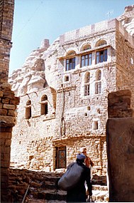
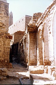
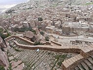
Thula is considered a very attractive place, which is almost entirely built from stone houses. These are sometimes five-story. The stones were taken from the quarries in the immediate vicinity, unless the quarries themselves - similar to, for example, at-Tawīla - served as construction pits. Binders (mortar) were not used. House walls, window frames and doors are artistically decorated. The medieval city is enclosed by a stone city wall from the 17th century, and the wooden city gates still exist. There are underground cisterns within the walls , which can be found especially in the nearby village of Hababah . The imam's house dates from the 16th century and is used as a fund , the mosque even from the 14th century. The castle hill fortress is uninhabited.
In addition to Shibam Kaukabān, Thula was the capital of the Yuʿfirids (7th / 8th centuries), later a refuge for the imams in the 16th century during the first Ottoman conquest .
Surrounding area
The region of the western mountain slopes is considered to be one of the most spectacular landscapes in Yemen. The valleys are deeply cut. This natural area is characterized by small chambers and the inaccessibility of the mountains. There is often a lack of patience, but this kept enemies in check. It is thanks to these circumstances that the tribal society in the highlands developed autochthonously over the centuries.
In order to be able to obtain agricultural products from the rare fertile soils, the population has always been dependent on terraced farming. For this purpose, species-rich dry forests have been cleared since ancient times . Succulent euphorbias (for example the Euphorbia ammak) have established themselves as natural vegetation . Coffee can be grown where the valleys spread.
particularities
In addition to Sanaa and At-Tawīlah, Thula also has Hijra status, based on the emigration of Muhammad and his followers from Mecca to Medina and his arrival in Qubāʾ on 12 Rabīʿ al-awwal = September 24, 622.
The fortress al-Mutahhar is considered an outstanding building of Islamic architecture .
Thula is one of five cities in Yemen on the preliminary World Heritage - Tentative .
See also
Individual evidence
- ↑ population statistics
- ↑ ( Page no longer available , search in web archives: World Gezatteer population data of the administrative unit Thula 2012 )
- ↑ Horst Kopp (ed.): Yemen geography . Reichert, Wiesbaden 2005, ISBN 3-89500-500-2 , see map .
- ↑ Gerhard Heck, Manfred Wöbcke: Arabian Peninsula . DuMont-Reiseverlag, 2011, ISBN 978-3-7701-7643-4 , p. 154 f . ( books.google.nl ).
- ↑ Travel report Yemen
- ↑ ( Page no longer available , search in web archives: brief information )
- ↑ Horst Kopp (ed.): Yemen geography . Reichert, Wiesbaden 2005, ISBN 3-89500-500-2 , p. 36-37 .
- ^ The Historic City of Thula
literature
- Edmund Jacoby: The visual world history of the Middle Ages . 1st edition. Gerstenberg, Hildesheim 2005, ISBN 3-8067-4594-3 .
- Horst Kopp (Ed.): Geography of Yemen . Reichert, Wiesbaden 2005, ISBN 3-89500-500-2 .


