Thyolo
| Thyolo | ||
|---|---|---|
|
|
||
| Coordinates | 16 ° 4 ′ S , 35 ° 8 ′ E | |

|
||
| Basic data | ||
| Country | Malawi | |
| Southern region | ||
| District | Thyolo | |
| ISO 3166-2 | MW-TH | |
| height | 900 m | |
| surface | - | |
| Metropolitan area | 1715 km² | |
| Residents | 7843 (2018) | |
| Metropolitan area | 458.976 | |
| density | - | |
| Metropolitan area | 267.6 Ew. / km² | |
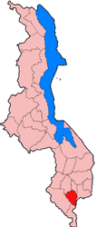
Thyolo denotes a town and a mountain (1462 m) at the southern end of the Shire highlands in Malawi and a district of 1715 km² with 458,976 inhabitants. The eastern slopes of the mountain form a large tea-growing area . The monsoons from the Indian Ocean ensure sufficient rainfall. The district capital of the same name with 7,843 inhabitants (2018 census) is located on the eastern slope of Mount Thyolo at an altitude of 900 meters. 42,000 people live in the immediate vicinity (2006 estimate). A single-lane paved road with paved gravel edges lead from Thyolo to Blantyre and gravel roads to Luchenza and Bangula on the Shire river. The city is connected to the power grid and has a small airfield a few kilometers to the west . The Malawian Lilongwe - Blantyre - Beira railway line can be reached in nearby Luchenza .
Despite the tea cultivation, Thyolo is considered a poor district. The lowest economic growth rates in Malawi in 1997/98 were concentrated in poor and overpopulated districts in the south, including Thyolo with 1.7%.

